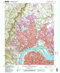
1992 Map of New Albany
USGS Topo · Published 1995About this map
The Ohio River dominates this mid-1990s landscape, serving as the border between New Albany and Louisville. Industrial and transit infrastructure is highly visible, featuring the McAlpine Locks, McAlpine Dam, and the Portland Canal bypassing the Falls of the Ohio. The map details the transition from the densely developed city centers to the elevated terrain of Floyds Knobs and Bald Knob to the northwest. Significant institutional presence is noted through the Indiana University Southeast Campus, the County Infirmary, and County Memorial Hospital. The suburban growth of the era is evident in the residential expansion of Clarksville and the numerous schools, such as New Albany High Sch and Scribner High Sch, that dot the Indiana side of the river. Legacy features like the Blackiston Mill on Silver Creek remain as markers of the area's earlier water-powered industry.
Find a feature on this map
116 named features on this map. Tap any name to fly to it.
Don’t see what you’re looking for? This feature index may not catch every label — zoom into the map to look around manually.
Map Details
Editions of this 1992 New Albany Map
2 editions found
Other maps of this area

1905 · Prospect
USGS Topo · 1:62,500

1907 · Louisville
USGS Topo · 1:62,500

1909 · Kosmosdale
USGS Topo · 1:48,000

1912 · Prospect
USGS Topo · 1:62,500

1912 · Kosmosdale
USGS Topo · 1:62,500

1937 · Jeffersonville
USGS Topo · 1:24,000

1937 · Charlestown
USGS Topo · 1:24,000

1938 · Speed
USGS Topo · 1:24,000

1939 · New Albany
USGS Topo · 1:24,000

1939 · Georgetown
USGS Topo · 1:24,000