1970s Maps of Crawford County, Indiana
Explore 5 historic maps of Crawford County from the 1970s. These maps offer a rare glimpse into what life looked like during the 1970s — showing old roads, neighborhoods, homes, and landmarks that have changed or disappeared over time.
Whether you're researching your family's past, planning a metal detecting trip, or studying how Crawford County's landscape evolved across the 1970s, these high-resolution maps are a powerful tool for exploring the history of this region.
- Focus on a specific era: All maps on this page are from the 1970s, giving you a focused view of this time period.
- See what’s changed: Compare century-old streets, trails, and buildings to today's modern landscape using overlays and satellite layers.
- Research with precision: Use these maps for genealogy, historical research, land use analysis, or educational projects.
- View, download, or print: Maps are fully viewable online in high resolution, and can be downloaded or printed for your own records.
Start exploring Crawford County's history through authentic maps from the 1970s. This is your window into the past.
Crawford County, IN maps
(5)- 1970 Map of Alton, 1972 Print
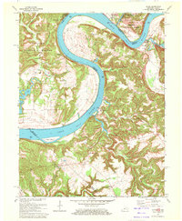 1970 Alton1972 Print · USGSThe Ohio River meanders between Indiana and Kentucky in the 1970s, shaping the life of riverfront towns and upland forests. Genealogists and historians can trace riverside settlements like Alton and Concordia, or find family landmarks such as St Theresa Academy and Owens Cem.
 - 1970 Map of Beechwood, 1972 Print
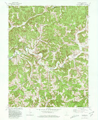
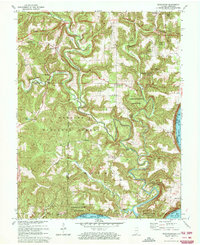 1970 Beechwood1972 Print · USGSSouthern Indiana's river bends and deep forests are captured here just as modern highway expansions were being planned in the early seventies. Local historians can trace family roots through numerous remote sites like Old Union Ch, Riddle Cem, and the Buzzard Roost Lookout Tower.2 unique versions available
 - 1970 Map of Leavenworth, 1972 Print
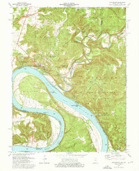 1970 Leavenworth1972 Print · USGSThe Ohio River valley near the Crawford and Harrison county line is captured here in the early seventies, centered on the historic river town of Leavenworth. Genealogists and hikers can trace old family burial sites like Mt Hope Ch Cem or explore landmarks such as Wyandotte Cave and the landing at Schooner Point Landing.3 unique versions available
 - 1970 Map of Valeene, 1972 Print
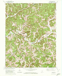 1970 Valeene1972 Print · USGSSouthern Indiana's rugged backcountry is shown in the early seventies, featuring the foundational surveying point for the entire state. Researchers can trace the Old Indian Treaty Boundary and locate family sites like Purkhiser Cem or the rural settlement of Valeene.
 - 1979 Map of Valeene, 1980 Print
 1979 Valeene1980 Print · USGSSouthern Indiana's heavily forested hills meet the waters of Patoka Lake in this late-seventies survey. Genealogists can trace family roots through rural communities like Valeene and Pearsontown or locate the historic Initial Point Historical Monument.
End of results
Showing maps 1-5 of 5
Top cities of Crawford County
Frequently asked questions
- What are the different types of historical maps available for Crawford County?
- What is the oldest map of Crawford County?
- Where can I purchase historical maps of Crawford County for my home or office?
- Where can I download high-res historical maps of Crawford County?
- Are there historical topographic maps available for Crawford County?
- Is there historical aerial imagery available for Crawford County?
- Where are historical maps of Crawford County sourced from?