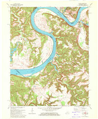
1970 Map of Alton
USGS Topo · Published 1972About this map
The Ohio River carves a massive, winding path through this 1970 landscape, defining the state boundary between Kentucky and Indiana. Along its steep banks, small riverfront communities like Alton and Concordia mark historic points of commerce and crossing, such as the Ferry Cross Roads Ch site. The terrain is notably varied, featuring the Buzzard Roost Overlook within the Boone Harrison-Crawford State Forest and the unusual geological depressions of the Jarbo Sinks further inland. Social life in the river hills is anchored by established institutions like St Theresa Academy and rural churches including Sacred Heart Ch and Cross Roads Ch. The map provides a look at the interplay of public land, including the Hoosier National Forest, and small-scale settlements such as Mooleyville and Rhodelia nestled in the valleys and hollows of Meade and Crawford counties.
Find a feature on this map
40 named features on this map. Tap any name to fly to it.
Don’t see what you’re looking for? This feature index may not catch every label — zoom into the map to look around manually.
Map Details
Editions of this 1970 Alton Map
This is the sole edition of this map. No revisions or reprints were ever made.
Other maps of this area

1928 · Hardinsburg
USGS Topo · 1:48,000

1931 · Hardinsburg
USGS Topo · 1:62,500

1934 · Cannelton
USGS Topo · 1:62,500

1946 · Leavenworth
USGS Topo · 1:24,000

1947 · Irvington
USGS Topo · 1:24,000

1947 · Lodiburg
USGS Topo · 1:24,000

1947 · Leavenworth
USGS Topo · 1:24,000

1947 · Hardinsburg
USGS Topo · 1:62,500

1950 · Beechwood
USGS Topo · 1:24,000
1950 · Leavenworth
USGS Topo · 1:24,000