1970s Maps of Daviess County, Indiana
Explore 8 historic maps of Daviess County from the 1970s. These maps offer a rare glimpse into what life looked like during the 1970s — showing old roads, neighborhoods, homes, and landmarks that have changed or disappeared over time.
Whether you're researching your family's past, planning a metal detecting trip, or studying how Daviess County's landscape evolved across the 1970s, these high-resolution maps are a powerful tool for exploring the history of this region.
- Focus on a specific era: All maps on this page are from the 1970s, giving you a focused view of this time period.
- See what’s changed: Compare century-old streets, trails, and buildings to today's modern landscape using overlays and satellite layers.
- Research with precision: Use these maps for genealogy, historical research, land use analysis, or educational projects.
- View, download, or print: Maps are fully viewable online in high resolution, and can be downloaded or printed for your own records.
Start exploring Daviess County's history through authentic maps from the 1970s. This is your window into the past.
Daviess County, IN maps
(8)- 1974 Map of Odon, 1976 Print
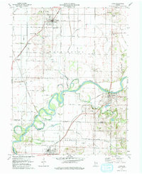
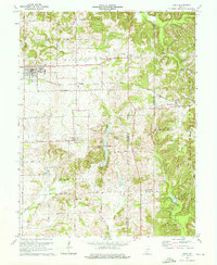 1974 Odon1976 Print · USGSDaviess and Martin counties are captured here in the mid-seventies, showing a rural landscape defined by small farming hamlets and the Chicago Milwaukee St Paul and Pacific line. Researchers can trace family roots through several country sites like Walnut Hill Cem, Shiloh Ch, and the settlement of Raglesville.2 unique versions available
 - 1974 Map of Loogootee, 1976 Print
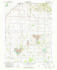
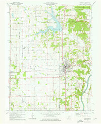 1974 Loogootee1976 Print · USGSLoogootee and the surrounding Indiana countryside are captured here in the mid-seventies as recreation and industry balanced against traditional farming life. Genealogists can locate family sites at St Johns Cemetery or Houghton Cem while tracing the Baltimore and Ohio rail line.2 unique versions available
 - 1974 Map of Glendale, 1976 Print
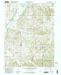
 1974 Glendale1976 Print · USGSDaviess County’s rural southern townships are captured in the mid-1970s as new conservation lands transformed the local landscape. Genealogists and historians can trace numerous country burial grounds and churches, from St Patricks Ch in Corning to Ebenezer Cem near the river forks.2 unique versions available
 - 1978 Map of Alfordsville
 1978 Alfordsville1978 Print · USGSDaviess and Martin counties are shown in the late 1970s as a landscape of river-bend settlements and active extraction. Genealogists can locate family landmarks like Alfordsville Cem, Inman Cem, and rural centers such as Whitfield and Portersville.
 - 1978 Map of Lyons, 1979 Print
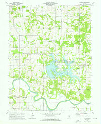
 1978 Lyons1979 Print · USGSSouthern Indiana river country is meticulously documented in the late seventies, centered on the White River and the rural communities of Lyons and Newberry. Genealogists and historians can trace old family burial grounds like Slinkard Cem and Bogard Cem or the rail junctions at Bushrod and Beehunter.2 unique versions available
 - 1978 Map of Epsom, 1979 Print
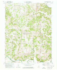
 1978 Epsom1979 Print · USGSDaviess County in the late seventies is a landscape of active coal mining and intersectional rail lines. Researchers can trace family history through numerous rural burial sites like Tolberts Chapel Cem and Fairview Cem or locate the old North Bogard Sch.2 unique versions available
 - 1979 Map of Montgomery
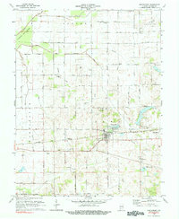 1979 Montgomery1979 Print · USGSDaviess County farmland and small-town life are captured in the late seventies along the busy Baltimore and Ohio railroad. Genealogists can trace local roots through rural landmarks like St Peters Cem, Berea Ch, and the Pleasant View Sch.
 - 1979 Map of Scotland
 1979 Scotland1979 Print · USGSSouthern Greene County is captured here in the late seventies, showing the junction of agricultural creek bottoms and large-scale military infrastructure. Researchers can trace family history through sites like Gilbreath Cem, Mineral City, and the Antioch Ch.3 unique versions available
End of results
Showing maps 1-8 of 8
Top cities of Daviess County
- Washington historical maps
- Odon historical maps
- Elnora historical maps
- Plainville historical maps
- Montgomery historical maps
- Cannelburg historical maps
See more
Frequently asked questions
- What are the different types of historical maps available for Daviess County?
- What is the oldest map of Daviess County?
- Where can I purchase historical maps of Daviess County for my home or office?
- Where can I download high-res historical maps of Daviess County?
- Are there historical topographic maps available for Daviess County?
- Is there historical aerial imagery available for Daviess County?
- Where are historical maps of Daviess County sourced from?