1990s Maps of DeKalb County, Indiana
Explore 6 historic maps of DeKalb County from the 1990s. These maps offer a rare glimpse into what life looked like during the 1990s — showing old roads, neighborhoods, homes, and landmarks that have changed or disappeared over time.
Whether you're researching your family's past, planning a metal detecting trip, or studying how DeKalb County's landscape evolved across the 1990s, these high-resolution maps are a powerful tool for exploring the history of this region.
- Focus on a specific era: All maps on this page are from the 1990s, giving you a focused view of this time period.
- See what’s changed: Compare century-old streets, trails, and buildings to today's modern landscape using overlays and satellite layers.
- Research with precision: Use these maps for genealogy, historical research, land use analysis, or educational projects.
- View, download, or print: Maps are fully viewable online in high resolution, and can be downloaded or printed for your own records.
Start exploring DeKalb County's history through authentic maps from the 1990s. This is your window into the past.
DeKalb County, IN maps
(6)- 1990 Map of Adrian, 1991 Print
 1990 Adrian1991 Print · USGSThe Michigan and Ohio borderlands come alive in the final decade of the twentieth century, showing the intricate network of glacial lakes and small-town junctions. Genealogists and local researchers can pinpoint family landmarks from Lakeview Cem to the rail sidings of the Conrail and Norfolk Southern lines.
 - 1992 Map of Hamilton, 1993 Print
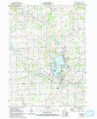 1992 Hamilton1993 Print · USGSNortheast Indiana's lake country is captured here in the early nineties, centered on the bustling shoreline of Hamilton Lake. Researchers can trace local lineage through numerous rural landmarks like South Scott Ch, Otsego Center Cem, and the historic settlement of Hamilton.
 - 1992 Map of Butler West, 1995 Print
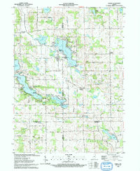
 1992 Butler West1995 Print · USGSDeKalb County farmland is captured here in the early nineties, revealing a landscape shaped by nineteenth-century infrastructure and rural parish life. Researchers can trace family history at Norris Chapel and Mt Pleasant Ch, or follow the path of the Old Railroad Grade near Taylor Corner.
 - 1993 Map of Ashley
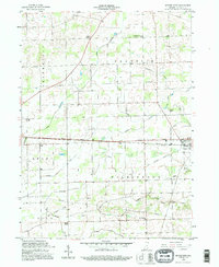
 1993 Ashley1993 Print · USGSThe Steuben and DeKalb county line in the early nineties highlights a landscape of interconnected glacial lakes and rail-oriented towns. Researchers can trace family sites at Hollister Cem and Mt Zion Ch or explore the rail corridor through Ashley and Hudson.
 - 1993 Map of Stroh
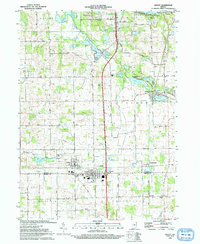
 1993 Stroh1993 Print · USGSNortheastern Indiana’s glaciated lake country is captured here in the early nineties, centered on the four-county junction. Trace family roots and local history at sites like Stroh, Salem Center, and the rural Weston Chapel Cem.
 - 1994 Map of Fort Wayne
 1994 Fort Wayne1994 Print · USGSNortheast Indiana in the mid-nineties shows a landscape deeply tied to its glacial lakes and early rail networks. Genealogists and historians can trace old transit lines like the Old Ind RR and explore lakeside settlements such as Enchanted Hills and Syracuse.
End of results
Showing maps 1-6 of 6
Top cities of DeKalb County
- Auburn historical maps
- Garrett historical maps
- Butler historical maps
- Waterloo historical maps
- Concord historical maps
- Ashley historical maps
See more
Frequently asked questions
- What are the different types of historical maps available for DeKalb County?
- What is the oldest map of DeKalb County?
- Where can I purchase historical maps of DeKalb County for my home or office?
- Where can I download high-res historical maps of DeKalb County?
- Are there historical topographic maps available for DeKalb County?
- Is there historical aerial imagery available for DeKalb County?
- Where are historical maps of DeKalb County sourced from?