1960s Maps of Smithfield, Indiana
Explore 2 historic maps of Smithfield from the 1960s. These maps offer a rare glimpse into what life looked like during the 1960s — showing old roads, neighborhoods, homes, and landmarks that have changed or disappeared over time.
Whether you're researching your family's past, planning a metal detecting trip, or studying how Smithfield's landscape evolved across the 1960s, these high-resolution maps are a powerful tool for exploring the history of this region.
- Focus on a specific era: All maps on this page are from the 1960s, giving you a focused view of this time period.
- See what’s changed: Compare century-old streets, trails, and buildings to today's modern landscape using overlays and satellite layers.
- Research with precision: Use these maps for genealogy, historical research, land use analysis, or educational projects.
- View, download, or print: Maps are fully viewable online in high resolution, and can be downloaded or printed for your own records.
Start exploring Smithfield's history through authentic maps from the 1960s. This is your window into the past.
Smithfield, IN maps
(2)- 1962 Map of Muncie East, 1964 Print
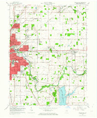 1962 Muncie East1964 Print · USGSMid-century Muncie and its eastern suburbs are shown here as the city expands toward the newly established Prairie Creek Reservoir. Genealogists and local historians can trace family roots through several rural burial grounds like Mt Tabor Cem and Parker Moore Cem, or locate long-standing landmarks like Reese Airport.
 - 1969 Map of Muncie East, 1971 Print
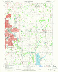 1969 Muncie East1971 Print · USGSThe eastern reaches of Muncie and its surrounding townships are shown here during a period of steady growth in the late sixties. Researchers can find well-documented family sites including Bortsfield Cem, the County Home, and the former Selma Airfield.3 unique versions available
End of results
Showing maps 1-2 of 2
Top cities near Smithfield
- Muncie historical maps
- New Castle historical maps
- Yorktown historical maps
- Eaton historical maps
- Redkey historical maps
- Farmland historical maps
See more
Frequently asked questions
- What are the different types of historical maps available for Smithfield?
- What is the oldest map of Smithfield?
- Where can I purchase historical maps of Smithfield for my home or office?
- Where can I download high-res historical maps of Smithfield?
- Are there historical topographic maps available for Smithfield?
- Is there historical aerial imagery available for Smithfield?
- Where are historical maps of Smithfield sourced from?