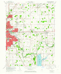
1962 Map of Muncie East
USGS Topo · Published 1964About this map
The White River and Prairie Creek Reservoir anchor this 1962 revision, illustrating the eastward expansion of Muncie and the surrounding township structures. Suburban growth is evident in residential developments like Indian Village, Echo Heights, and Mayfield, which contrast with the industrial and transit-heavy sectors defined by the New York Central and Chesapeake and Ohio railroads. The map records a dense network of local education and social infrastructure, including Kuhner Jr High Sch and several neighborhood cemeteries such as Bortsfield Cem and White Cem. Outside the urban center, the landscape remains focused on resource extraction and leisure, marked by numerous Oil Wells and the Delaware Country Club. This document captures the transition between Muncie's industrial heritage and the developing recreational and residential spaces of eastern Delaware County.
Find a feature on this map
74 named features on this map. Tap any name to fly to it.
Don’t see what you’re looking for? This feature index may not catch every label — zoom into the map to look around manually.
Map Details
Editions of this 1962 Muncie East Map
This is the sole edition of this map. No revisions or reprints were ever made.
Other maps of this area

1952 · Muncie East
USGS Topo · 1:24,000

1952 · Farmland
USGS Topo · 1:24,000

1952 · Muncie West
USGS Topo · 1:24,000

1953 · Muncie
USGS Topo · 1:250,000

1956 · Muncie
USGS Topo · 1:250,000

1960 · Eaton
USGS Topo · 1:24,000

1960 · Mount Pleasant
USGS Topo · 1:24,000

1960 · Wheeling
USGS Topo · 1:24,000

1960 · Sulphur Springs
USGS Topo · 1:24,000
1960 · Modoc
USGS Topo · 1:24,000