1960s Maps of Wakarusa, Indiana
Explore 2 historic maps of Wakarusa from the 1960s. These maps offer a rare glimpse into what life looked like during the 1960s — showing old roads, neighborhoods, homes, and landmarks that have changed or disappeared over time.
Whether you're researching your family's past, planning a metal detecting trip, or studying how Wakarusa's landscape evolved across the 1960s, these high-resolution maps are a powerful tool for exploring the history of this region.
- Focus on a specific era: All maps on this page are from the 1960s, giving you a focused view of this time period.
- See what’s changed: Compare century-old streets, trails, and buildings to today's modern landscape using overlays and satellite layers.
- Research with precision: Use these maps for genealogy, historical research, land use analysis, or educational projects.
- View, download, or print: Maps are fully viewable online in high resolution, and can be downloaded or printed for your own records.
Start exploring Wakarusa's history through authentic maps from the 1960s. This is your window into the past.
Wakarusa, IN maps
(2)- 1960 Map of Foraker, 1961 Print
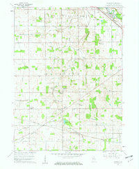 1960 Foraker1961 Print · USGSElkhart County farmland is depicted here in the early sixties, showing a landscape defined by organized drainage and rural community life. Researchers can locate numerous family-named landmarks and old country churches like Wisler Ch, Wenger Cem, and the settlement of Foraker.4 unique versions available
 - 1961 Map of Wakarusa, 1963 Print
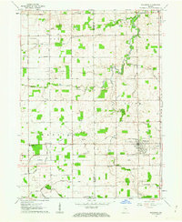 1961 Wakarusa1963 Print · USGSIn the early 1960s, the rural borderlands of Elkhart and St. Joseph counties remained a landscape of family-named drainage ditches and country congregations. Genealogists and local researchers can trace the vicinity of Wakarusa to find Holdeman Ch, Resthaven Cem, and Township High Sch.3 unique versions available
End of results
Showing maps 1-2 of 2
Top cities near Wakarusa
- South Bend historical maps
- Elkhart historical maps
- Mishawaka historical maps
- Goshen historical maps
- Granger historical maps
- Nappanee historical maps
See more
Frequently asked questions
- What are the different types of historical maps available for Wakarusa?
- What is the oldest map of Wakarusa?
- Where can I purchase historical maps of Wakarusa for my home or office?
- Where can I download high-res historical maps of Wakarusa?
- Are there historical topographic maps available for Wakarusa?
- Is there historical aerial imagery available for Wakarusa?
- Where are historical maps of Wakarusa sourced from?