1960s Maps of Mackey, Indiana
Explore 2 historic maps of Mackey from the 1960s. These maps offer a rare glimpse into what life looked like during the 1960s — showing old roads, neighborhoods, homes, and landmarks that have changed or disappeared over time.
Whether you're researching your family's past, planning a metal detecting trip, or studying how Mackey's landscape evolved across the 1960s, these high-resolution maps are a powerful tool for exploring the history of this region.
- Focus on a specific era: All maps on this page are from the 1960s, giving you a focused view of this time period.
- See what’s changed: Compare century-old streets, trails, and buildings to today's modern landscape using overlays and satellite layers.
- Research with precision: Use these maps for genealogy, historical research, land use analysis, or educational projects.
- View, download, or print: Maps are fully viewable online in high resolution, and can be downloaded or printed for your own records.
Start exploring Mackey's history through authentic maps from the 1960s. This is your window into the past.
Mackey, IN maps
(2)- 1961 Map of Elberfeld, 1963 Print
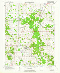 1961 Elberfeld1963 Print · USGSThe rural landscape around Elberfeld and Buckskin in the early sixties was a unique blend of active energy production and historical transit routes. Local historians can trace the path of the Erie and Wabash Canal and locate family sites like Nobles Cem or Zion Cem.4 unique versions available
 - 1961 Map of Francisco, 1963 Print
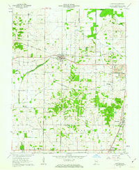 1961 Francisco1963 Print · USGSGibson County at the start of the sixties reveals a landscape of rural townships and evolving industry. Genealogists and local historians can trace family church sites like Providence Ch, explore the small town of Francisco, and locate the Old Indian Treaty Boundary.3 unique versions available
End of results
Showing maps 1-2 of 2
Top cities near Mackey
- Evansville historical maps
- Princeton historical maps
- Boonville historical maps
- Chandler historical maps
- Oakland City historical maps
- Fort Branch historical maps
See more
Frequently asked questions
- What are the different types of historical maps available for Mackey?
- What is the oldest map of Mackey?
- Where can I purchase historical maps of Mackey for my home or office?
- Where can I download high-res historical maps of Mackey?
- Are there historical topographic maps available for Mackey?
- Is there historical aerial imagery available for Mackey?
- Where are historical maps of Mackey sourced from?