1950s Maps of Grant County, Indiana
Explore 8 historic maps of Grant County from the 1950s. These maps offer a rare glimpse into what life looked like during the 1950s — showing old roads, neighborhoods, homes, and landmarks that have changed or disappeared over time.
Whether you're researching your family's past, planning a metal detecting trip, or studying how Grant County's landscape evolved across the 1950s, these high-resolution maps are a powerful tool for exploring the history of this region.
- Focus on a specific era: All maps on this page are from the 1950s, giving you a focused view of this time period.
- See what’s changed: Compare century-old streets, trails, and buildings to today's modern landscape using overlays and satellite layers.
- Research with precision: Use these maps for genealogy, historical research, land use analysis, or educational projects.
- View, download, or print: Maps are fully viewable online in high resolution, and can be downloaded or printed for your own records.
Start exploring Grant County's history through authentic maps from the 1950s. This is your window into the past.
Grant County, IN maps
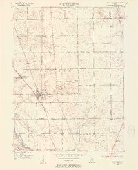
(8)- 1950 Map of Warren, 1965 Print
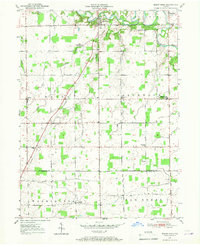
 1950 Warren1965 Print · USGSMid-century Huntington County is defined by the river-and-rail intersection at Warren during a period of steady agricultural growth. Genealogists can trace family names and sites at Redmen Cem, Plum Tree, and the Water Methodist Home.
 - 1950 Map of Mount Etna, 1967 Print
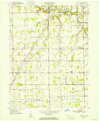
 1950 Mount Etna1967 Print · USGSThe Huntington and Grant County line bisects this quiet agricultural landscape during the post-war era. Researchers can trace the development of rural social life through landmarks like Salem Ch, the Jefferson Twp Consolidated Sch, and the grounds of the Star Commonwealth For Boys.
 - 1951 Map of Mount Etna
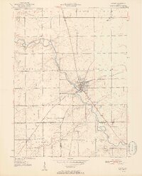
 1951 Mount Etna1951 Print · USGSIndiana's rural heartland is meticulously mapped here in the early fifties, documenting a landscape of small farming communities and river valleys. Genealogists can trace family roots through sites like Pormance Cem, the Jefferson Twp Consolidated Sch, and the settlement at Banquo.2 unique versions available
 - 1952 Map of Warren
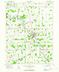
 1952 Warren1952 Print · USGSNortheastern Indiana farmland surrounds the hub of Warren during the early fifties, as the river and rail economy remained the backbone of the county. Genealogists and local historians can locate early burial sites like Taylor Cem and Redmen Cem or trace the New York Chicago and St Louis rail line.2 unique versions available
 - 1953 Map of La Fontaine, 1954 Print
 1953 La Fontaine1954 Print · USGSMid-century Wabash and Grant Counties come to life as small-town Indiana centers around the New York Central rail line. Genealogists can trace family roots through numerous burial sites like America Cem, Hale Cem, and the Boundary Line Ch.2 unique versions available
 - 1953 Map of Somerset, 1954 Print
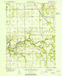 1953 Somerset1954 Print · USGSThe Mississinewa River valley in the early 1950s reveals a network of historic trails and river-dependent settlements across the Wabash and Grant county border. Genealogists can trace family roots at Sugar Grove Cem and Union Chapel, or locate forgotten sites like Pearson Mill.2 unique versions available
 - 1953 Map of Muncie, 1966 Print
 1953 Muncie1966 Print · USGSIndiana and Ohio borderlands thrive in the early fifties, showing a landscape defined by manufacturing cities and an intensive railroad network. Genealogists can trace family roots across the Indiana-Ohio line through Muncie, Celina, and Portland via the Pennsylvania railroad.5 unique versions available
 - 1956 Map of Muncie
 1956 Muncie1956 Print · USGSEastern Indiana and western Ohio are shown at a peak of rail-driven industry in the mid-fifties. Genealogists and rail historians can trace the paths of the Pennsylvania RR through Muncie or locate landmarks like Lake Saint Marys (Grand Lake Reservoir) and Frances Slocum State Forest.
End of results
Showing maps 1-8 of 8
Top cities of Grant County
- Marion historical maps
- Gas City historical maps
- Upland historical maps
- Fairmount historical maps
- Sims historical maps
- Jonesboro historical maps
See more
Frequently asked questions
- What are the different types of historical maps available for Grant County?
- What is the oldest map of Grant County?
- Where can I purchase historical maps of Grant County for my home or office?
- Where can I download high-res historical maps of Grant County?
- Are there historical topographic maps available for Grant County?
- Is there historical aerial imagery available for Grant County?
- Where are historical maps of Grant County sourced from?