1960s Maps of Grant County, Indiana
Explore 12 historic maps of Grant County from the 1960s. These maps offer a rare glimpse into what life looked like during the 1960s — showing old roads, neighborhoods, homes, and landmarks that have changed or disappeared over time.
Whether you're researching your family's past, planning a metal detecting trip, or studying how Grant County's landscape evolved across the 1960s, these high-resolution maps are a powerful tool for exploring the history of this region.
- Focus on a specific era: All maps on this page are from the 1960s, giving you a focused view of this time period.
- See what’s changed: Compare century-old streets, trails, and buildings to today's modern landscape using overlays and satellite layers.
- Research with precision: Use these maps for genealogy, historical research, land use analysis, or educational projects.
- View, download, or print: Maps are fully viewable online in high resolution, and can be downloaded or printed for your own records.
Start exploring Grant County's history through authentic maps from the 1960s. This is your window into the past.
Grant County, IN maps
(12)- 1960 Map of Point Isabel, 1961 Print
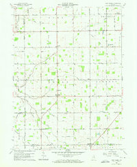 1960 Point Isabel1961 Print · USGSAgricultural life in central Indiana comes into focus during the early sixties, showing a landscape of small crossroads and family-named ditches. Genealogists can locate Antioch Ch, Knox Chapel, and the settlement of Point Isabel.4 unique versions available
 - 1960 Map of Fairmount, 1961 Print
 1960 Fairmount1961 Print · USGSFairmount and Jonesboro stand at the center of this 1960s Grant County landscape, split by two major railroads and an old treaty line. Genealogists can locate family sites near Hill Chapel, Little Ridge Cem, and the small community of Weaver.3 unique versions available
 - 1960 Map of Gas City, 1961 Print
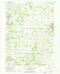
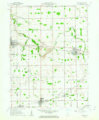
 1960 Gas City1961 Print · USGSGrant County is shown during a period of steady growth and industrial rail activity in the early sixties. Genealogists and historians can locate family plots at Riverside Cem or trace the early paths of the PENNSYLVANIA and CHESAPEAKE AND OHIO railroads.4 unique versions available
 - 1960 Map of Hartford City West, 1976 Print
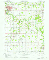
 1960 Hartford City West1976 Print · USGSIndiana's farm and college country comes to life in the late fifties, centered on the growing communities of Hartford City and Upland. Researchers can locate the Purdue University Memorial Farm, the Covered Bridge near Matthews, and several rural landmarks like Shiloh Cem.5 unique versions available
 - 1961 Map of Marion, 1963 Print
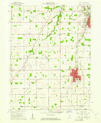
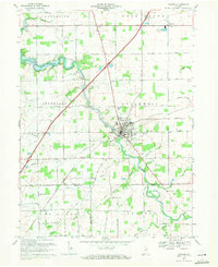
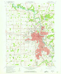 1961 Marion1963 Print · USGSMarion emerges as a thriving mid-century industrial center at the intersection of the Mississinewa River and multiple rail lines in the early sixties. Genealogists and historians can locate numerous neighborhood landmarks, including Marion College, the IOOF Cemetery, and the Goodman Yards rail facility.3 unique versions available
 - 1962 Map of Sweetser, 1963 Print
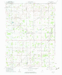
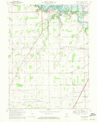
 1962 Sweetser1963 Print · USGSGrant County in the early sixties was a hub of rural industry and local rail transport. Genealogists and historians can trace family roots at Thrailkill Cemetery, explore the rail sidings of Swayzee, or locate the Richland Chapel and Oak Hill High School.
 - 1962 Map of Roll, 1963 Print
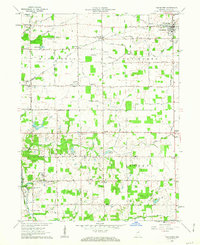
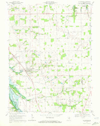
 1962 Roll1963 Print · USGSBlackford and Wells counties in the early sixties remained a deeply rural landscape of grain fields and drainage canals. Family historians can trace ancestral sites like Oak Chapel, the Township Sch, and local burial grounds such as Balsley Cem and Center Cem.3 unique versions available
 - 1962 Map of Van Buren, 1963 Print
 1962 Van Buren1963 Print · USGSGrant County is captured in the early sixties as a structured grid of family farms and railroad hamlets. Researchers can trace the legacy of small-town Indiana through landmarks like Landess, Roosevelt Sch, and the Locust Chapel.2 unique versions available
 - 1969 Map of Somerset, 1971 Print
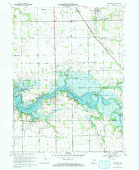 1969 Somerset1971 Print · USGSThe Wabash County countryside was being transformed by the rising Mississinewa Reservoir in the late sixties. Genealogists and local historians can trace the foundations of Somerset, locate the White Institute, and identify rural landmarks like Lebanon Ch and Treaty.3 unique versions available
 - 1969 Map of Warren, 1971 Print
 1969 Warren1971 Print · USGSWarren and its rural surroundings are captured in the late sixties, showing a landscape defined by the Salamonie River and local petroleum extraction. Researchers can trace family history at West Union Cem or locate the old Airfield and Milo settlement along the rail lines.2 unique versions available
 - 1969 Map of Mount Etna, 1971 Print
 1969 Mount Etna1971 Print · USGSIndiana's rural heartland is captured here in the late sixties as the newly created Salamonie Reservoir reshaped the northern townships. Genealogists and local historians can locate early burial sites like Purviance Cem, and vanished school sites like Township Sch.2 unique versions available
 - 1969 Map of La Fontaine, 1972 Print
 1969 La Fontaine1972 Print · USGSThe rural borderlands of Wabash and Grant counties are captured here in the late sixties as modern reservoirs began to shape the landscape. Local historians can trace family plots at Boundary Line Cem and Gardner Cem or follow the path of the Penn Central through La Fontaine.2 unique versions available
End of results
Showing maps 1-12 of 12
Top cities of Grant County
- Marion historical maps
- Gas City historical maps
- Upland historical maps
- Fairmount historical maps
- Sims historical maps
- Jonesboro historical maps
See more
Frequently asked questions
- What are the different types of historical maps available for Grant County?
- What is the oldest map of Grant County?
- Where can I purchase historical maps of Grant County for my home or office?
- Where can I download high-res historical maps of Grant County?
- Are there historical topographic maps available for Grant County?
- Is there historical aerial imagery available for Grant County?
- Where are historical maps of Grant County sourced from?