1990s Maps of Limb Town, Indiana
Explore 2 historic maps of Limb Town from the 1990s. These maps offer a rare glimpse into what life looked like during the 1990s — showing old roads, neighborhoods, homes, and landmarks that have changed or disappeared over time.
Whether you're researching your family's past, planning a metal detecting trip, or studying how Limb Town's landscape evolved across the 1990s, these high-resolution maps are a powerful tool for exploring the history of this region.
- Focus on a specific era: All maps on this page are from the 1990s, giving you a focused view of this time period.
- See what’s changed: Compare century-old streets, trails, and buildings to today's modern landscape using overlays and satellite layers.
- Research with precision: Use these maps for genealogy, historical research, land use analysis, or educational projects.
- View, download, or print: Maps are fully viewable online in high resolution, and can be downloaded or printed for your own records.
Start exploring Limb Town's history through authentic maps from the 1990s. This is your window into the past.
Limb Town, IN maps
(2)- 1992 Map of Marion, 1995 Print
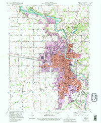 1992 Marion1995 Print · USGSMarion and its surrounding Grant County townships appear here during the mid-1990s as the riverfront and rail lines continue to shape the community. Researchers can locate dozens of civic landmarks including Marion College, the VA Hospital, and Grant Memorial Park.
 - 1992 Map of Van Buren, 1995 Print
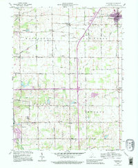 1992 Van Buren1995 Print · USGSGrant County farmland meets the modern Interstate era in this detailed survey of the Indiana countryside during the 1990s. Genealogists can trace family footprints at Fairview Cem or Landess Cem and locate rural landmarks like Locust Chapel and Roosevelt Sch.
End of results
Showing maps 1-2 of 2
Top cities near Limb Town
- Marion historical maps
- Wabash historical maps
- Gas City historical maps
- Upland historical maps
- Fairmount historical maps
- Sims historical maps
See more
Frequently asked questions
- What are the different types of historical maps available for Limb Town?
- What is the oldest map of Limb Town?
- Where can I purchase historical maps of Limb Town for my home or office?
- Where can I download high-res historical maps of Limb Town?
- Are there historical topographic maps available for Limb Town?
- Is there historical aerial imagery available for Limb Town?
- Where are historical maps of Limb Town sourced from?