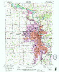
1992 Map of Marion
USGS Topo · Published 1995About this map
The Mississinewa River cuts a wide, meandering path through Grant County, anchoring the development of Marion during the early 1990s. This urban center is characterized by a dense network of civic and educational institutions, including Marion College and a significant VA Hospital complex near Home Corner. The landscape transitions from the developed city core to rural townships like Pleasant and Franklin, where small settlements such as Michaelsville and Roseburg persist. Genealogy interest is concentrated in the numerous burial grounds, including Grant Memorial Park (Cemetery) and the IOOF Cemetery. Significant infrastructure is visible along the Conrail line and historical routes like the Slocum Trail. To the north, the Mississinewa Lake State Wildlife Management and Recreation Area marks a shift toward protected natural terrain, contrasting with the structured grid of the city.
Find a feature on this map
88 named features on this map. Tap any name to fly to it.
Don’t see what you’re looking for? This feature index may not catch every label — zoom into the map to look around manually.
Map Details
Editions of this 1992 Marion Map
This is the sole edition of this map. No revisions or reprints were ever made.
Other maps of this area

1950 · Mount Etna
USGS Topo · 1:24,000

1951 · Mount Etna
USGS Topo · 1:24,000

1953 · La Fontaine
USGS Topo · 1:24,000

1953 · Somerset
USGS Topo · 1:24,000

1953 · Muncie
USGS Topo · 1:250,000

1956 · Muncie
USGS Topo · 1:250,000

1960 · Point Isabel
USGS Topo · 1:24,000

1960 · Fairmount
USGS Topo · 1:24,000

1960 · Gas City
USGS Topo · 1:24,000

1961 · Marion
USGS Topo · 1:24,000