
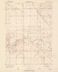
1953 Map of Somerset
USGS Topo · Published 1954About this map
The Mississinewa River winds through this 1950s landscape, its deep bends and oxbows defining the geography between the Wabash and Grant county lines. Along its banks, the Slocum Trail and Mount Vernon Trail follow the river's course, connecting local landmarks such as Pearson Mill and the community of Somerset. This survey preserves the location of numerous country burying grounds and places of worship, including Sugar Grove Cem, Martin Luther Cem, and Lebanon Ch, which served the rural populations of Waltz and Liberty townships. The northeastern corner is bisected by the New York Central railroad, passing through the small settlement of Treaty. A notable topographic feature known as The Hogback stands out as a sharp ridge formed by a dramatic meander in the river channel.
Find a feature on this map
37 named features on this map. Tap any name to fly to it.
Don’t see what you’re looking for? This feature index may not catch every label — zoom into the map to look around manually.
Map Details
Editions of this 1953 Somerset Map
2 editions found
Other maps of this area

1950 · Lagro
USGS Topo · 1:24,000

1951 · Lagro
USGS Topo · 1:24,000

1951 · Richvalley
USGS Topo · 1:24,000

1952 · Wabash
USGS Topo · 1:24,000

1953 · La Fontaine
USGS Topo · 1:24,000

1953 · Peoria
USGS Topo · 1:24,000

1953 · Muncie
USGS Topo · 1:250,000

1956 · Muncie
USGS Topo · 1:250,000

1961 · Marion
USGS Topo · 1:24,000
1962 · Amboy
USGS Topo · 1:24,000