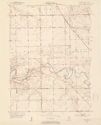
1953 Map of Somerset
USGS Topo · Published 1954About this map
Mississinewa River winding through the heart of Somerset and its neighboring townships defines the landscape of this mid-century Wabash County survey. The area is marked by a deep-rooted rural infrastructure, featuring landmarks like the White Institute and Pearson Mill. Transportation and historical transit routes are prominent, with the New York Central railroad corridor cutting through the northeast and the Frances Slocum Trail following the river's path. The terrain is notably varied, highlighted by a distinctive formation known as The Hogback near a bend in the river. Local genealogy is well-represented through numerous community anchors, including Maple Grove School, Union Chapel, and several family or church burial grounds such as Mount Vernon Cem and Martin Luther Cem. Small clusters of development at Riverside and Treaty illustrate the dispersed settlement pattern characteristic of the region before significant modern alteration.
Find a feature on this map
33 named features on this map. Tap any name to fly to it.
Don’t see what you’re looking for? This feature index may not catch every label — zoom into the map to look around manually.
Map Details
Editions of this 1953 Somerset Map
2 editions found
Other maps of this area

1950 · Lagro
USGS Topo · 1:24,000

1951 · Lagro
USGS Topo · 1:24,000

1951 · Richvalley
USGS Topo · 1:24,000

1952 · Wabash
USGS Topo · 1:24,000

1953 · La Fontaine
USGS Topo · 1:24,000

1953 · Somerset
USGS Topo · 1:24,000

1953 · Peoria
USGS Topo · 1:24,000

1953 · Muncie
USGS Topo · 1:250,000

1956 · Muncie
USGS Topo · 1:250,000

1961 · Marion
USGS Topo · 1:24,000