1960s Maps of Hancock County, Indiana
Explore 8 historic maps of Hancock County from the 1960s. These maps offer a rare glimpse into what life looked like during the 1960s — showing old roads, neighborhoods, homes, and landmarks that have changed or disappeared over time.
Whether you're researching your family's past, planning a metal detecting trip, or studying how Hancock County's landscape evolved across the 1960s, these high-resolution maps are a powerful tool for exploring the history of this region.
- Focus on a specific era: All maps on this page are from the 1960s, giving you a focused view of this time period.
- See what’s changed: Compare century-old streets, trails, and buildings to today's modern landscape using overlays and satellite layers.
- Research with precision: Use these maps for genealogy, historical research, land use analysis, or educational projects.
- View, download, or print: Maps are fully viewable online in high resolution, and can be downloaded or printed for your own records.
Start exploring Hancock County's history through authentic maps from the 1960s. This is your window into the past.
Hancock County, IN maps
(8)- 1960 Map of Knightstown, 1961 Print
 1960 Knightstown1961 Print · USGSKnightstown and the Big Blue River valley are captured in the early sixties as major rail lines and the historic National Road still defined local commerce. Researchers can trace family sites like Glencove Cem, the Morton Sch, and the small community of Raysville.3 unique versions available
 - 1960 Map of Shirley, 1961 Print
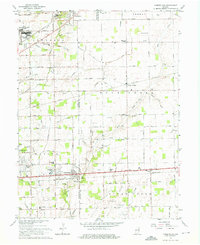
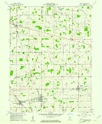 1960 Shirley1961 Print · USGSEast-central Indiana farmland is captured here in the early sixties, centered on the tri-county junction where Shirley meets the NEW YORK CENTRAL line. Local historians can trace family-named landmarks and rural hubs like McCray Cem, Harlan Ch, and the Township High Sch.2 unique versions available
 - 1962 Map of Mc Cordsville, 1963 Print
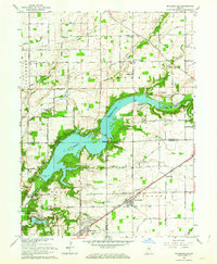 1962 Mc Cordsville1963 Print · USGSThe Geist Reservoir area undergoes a mid-century transformation where rural crossroads meet new lakeside developments. Researchers can trace ancestral sites at Arnett Cem or the rail history of McCordsville along the New York Central line.3 unique versions available
 - 1962 Map of Ingalls, 1963 Print
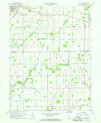
 1962 Ingalls1963 Print · USGSAs the mid-century suburban shift began to reach central Indiana, this area saw traditional farming intersect with growing communities and institutional landmarks. Genealogists can trace family names through sites like Hiday Cem, Beech Grove Ch, and the State Reformatory.3 unique versions available
 - 1962 Map of Greenfield, 1964 Print
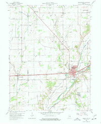
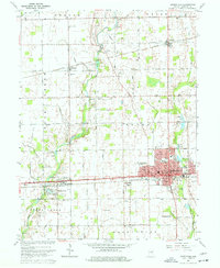 1962 Greenfield1964 Print · USGSGreenfield and central Hancock County are shown in the early sixties as the regional rail and road networks reached their mid-century peak. Genealogists can trace family landmarks and rural life through Nazarene Ch, Philadelphia, and the Owen Cem.5 unique versions available
 - 1962 Map of Cumberland, 1964 Print
 1962 Cumberland1964 Print · USGSCumberland and the eastern fringes of Indianapolis are shown here during a period of significant mid-century expansion. Researchers can trace family history through dozens of named burial grounds like Eastes Cem or locate defunct landmarks such as the Drive-in Theater and Fort Benjamin Harrison.5 unique versions available
 - 1962 Map of Acton, 1964 Print
 1962 Acton1964 Print · USGSThe rural-to-suburban transition east of Indianapolis is captured here in the early sixties, where traditional farmland meets new housing estates. Researchers can trace ancestral roots at Freeman Cem or follow the historic tracks of the New York Central through Acton.4 unique versions available
 - 1966 Map of Pendleton, 1968 Print
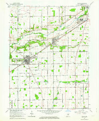
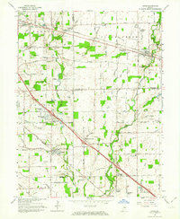
 1966 Pendleton1968 Print · USGSMadison and Hancock Counties are captured here in the mid-1960s, showing a landscape of small crossroads settlements and family farms. Trace local history through landmarks like Milners Corner, the Zion Chapel, and old family plots like Cook Cem.
End of results
Showing maps 1-8 of 8
Top cities of Hancock County
- Greenfield historical maps
- Fortville historical maps
- New Palestine historical maps
- McCordsville historical maps
- Wilkinson historical maps
- Spring Lake historical maps
Frequently asked questions
- What are the different types of historical maps available for Hancock County?
- What is the oldest map of Hancock County?
- Where can I purchase historical maps of Hancock County for my home or office?
- Where can I download high-res historical maps of Hancock County?
- Are there historical topographic maps available for Hancock County?
- Is there historical aerial imagery available for Hancock County?
- Where are historical maps of Hancock County sourced from?