1950s Maps of Harrison County, Indiana
Explore 23 historic maps of Harrison County from the 1950s. These maps offer a rare glimpse into what life looked like during the 1950s — showing old roads, neighborhoods, homes, and landmarks that have changed or disappeared over time.
Whether you're researching your family's past, planning a metal detecting trip, or studying how Harrison County's landscape evolved across the 1950s, these high-resolution maps are a powerful tool for exploring the history of this region.
- Focus on a specific era: All maps on this page are from the 1950s, giving you a focused view of this time period.
- See what’s changed: Compare century-old streets, trails, and buildings to today's modern landscape using overlays and satellite layers.
- Research with precision: Use these maps for genealogy, historical research, land use analysis, or educational projects.
- View, download, or print: Maps are fully viewable online in high resolution, and can be downloaded or printed for your own records.
Start exploring Harrison County's history through authentic maps from the 1950s. This is your window into the past.
Harrison County, IN maps
(23)- 1950 Map of Fort Knox
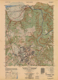 1950 Fort Knox1950 Print · USGSFort Knox and its surroundings in the years following the war show a landscape transformed by military necessity and river valley geography. Researchers can trace the layout of the US Bullion Depository and Godman Field alongside older communities like West Point and Goldville.
 - 1950 Map of Laconia
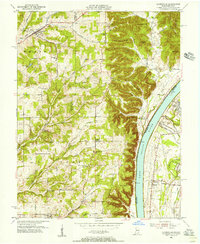
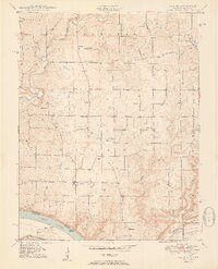 1950 Laconia1950 Print · USGSHarrison County settlement patterns are preserved here in the mid-twentieth century, centered on the riverfront and the rural crossroads of Laconia. Researchers can trace dozens of family cemeteries like Ferree Cem and vanished landmarks like Rehoboth Sch or Tobacco Landing.2 unique versions available
 - 1950 Map of Palmyra
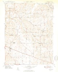 1950 Palmyra1950 Print · USGSMid-century Harrison and Washington counties are documented here at a time when small rural settlements like Martinsburg and Palmyra anchored the local landscape. Genealogists can trace family footprints through sites like Snyders Chapel, Miller Cem, and the Morgan Township Sch.2 unique versions available
 - 1950 Map of Leavenworth, 1954 Print
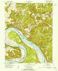 1950 Leavenworth1954 Print · USGSThe Ohio River meanders through Crawford County in the mid-century, showcasing a landscape of dramatic river bends and timbered highlands. Genealogists and local historians can trace family locations near Mt Hope Ch, Peckenpaugh Sch, or the riverside settlement of Leavenworth.3 unique versions available
 - 1950 Map of New Amsterdam, 1954 Print
 1950 New Amsterdam1954 Print · USGSThe Ohio River frontier in the early fifties reveals a landscape of isolated ridges and riverside hamlets. Genealogists can trace family footprints at Ball Knob Cem or locate former schoolhouses like Mint Springs Sch and Liberty Sch.2 unique versions available
 - 1950 Map of Mauckport, 1954 Print
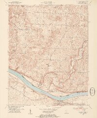 1950 Mauckport1954 Print · USGSAlong the Indiana-Kentucky border at the start of the fifties, the Ohio River connects bustling towns and quiet forest ridges. Researchers can trace historic river access at Morvin Landing, visit family sites like Atwell Cem, or locate landmarks such as Wesley Chapel and the Oak Grove Sch.3 unique versions available
 - 1950 Map of Corydon, 1959 Print
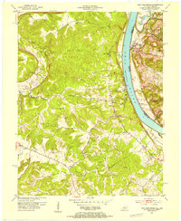
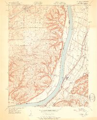
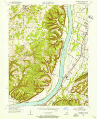
 1950 Corydon1959 Print · USGSSouthern Indiana and northern Kentucky are captured here in the mid-fifties, centered on the historic town of Corydon and the banks of the Ohio River. Researchers can trace rural life through sites like Sky Park Airport, St Peters Ch, and the river crossing at Mauckport.
 - 1950 Map of Alton, 1959 Print
 1950 Alton1959 Print · USGSThe Ohio River loops through the Indiana and Kentucky borderlands at mid-century, following the deep curves of Big Bend and Oxbow Bend. Genealogists and local historians can trace family roots through numerous rural landmarks like St Theresa Academy, Beechland Sch, and the historic town of Leavenworth.2 unique versions available
 - 1950 Map of Kosmosdale, 1959 Print
 1950 Kosmosdale1959 Print · USGSGreater Louisville and the Ohio River valley are captured here at mid-century, showing the city's industrial south side meeting rural river towns. Genealogists and historians can trace family locations through Lanesville Cem, the Waverly Hills Sanatorium, and Churchill Downs.
 - 1951 Map of Kosmosdale
 1951 Kosmosdale1951 Print · USGSThe Ohio River valley south of Louisville was a busy corridor of rail and road commerce in the early fifties. Genealogists and historians can trace local landmarks like Kosmosdale Sch, Mill Creek Cem, and the boundaries of the Fort Knox Military Reservation.2 unique versions available
 - 1951 Map of Lanesville
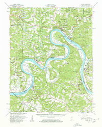
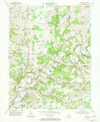
 1951 Lanesville1951 Print · USGSHarrison County and the Ohio River valley appear here in the early fifties, showing a rural landscape of ridge-top farms and river landings. Genealogists can trace family names through sites like Shoemaker Cem, Lottick Corner, and Seven Springs Sch.2 unique versions available
 - 1952 Map of Georgetown
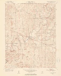
 1952 Georgetown1952 Print · USGSGeorgetown and Floyd County are captured here in the early fifties, showing a landscape of deep hollows and high ridges. Researchers can trace the SOUTHERN rail line through the TUNNEL or locate family burial sites like Wolf Cem and Buttontown Cem.
 - 1953 Map of Fredericksburg, 1954 Print
 1953 Fredericksburg1954 Print · USGSFredericksburg and the winding Blue River valley are captured here in the early fifties, showing a rural landscape defined by karst topography and river bottoms. Researchers can trace family history at the Roland Voyles Cem, visit Greene Mill, or locate the Adams Sch.2 unique versions available
 - 1954 Map of Evansville
 1954 Evansville1954 Print · USGSThe Ohio River borderlands between Indiana and Kentucky appear here during a period of robust industrial and military growth. Genealogists and researchers can trace the rail corridors of the Illinois Central and find landmarks like US Lock and Dam No 48 or Camp Breckinridge.
 - 1954 Map of Crandall, 1955 Print
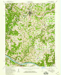
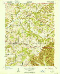
 1954 Crandall1955 Print · USGSHarrison County settlement patterns and rural life are documented here in the mid-fifties as the Southern railroad serviced small towns. Researchers can locate family roots at Old German Ch, trace the post office at Corydon Junction, or explore the crossroads at Byrneville.4 unique versions available
 - 1955 Map of Kosmosdale, 1956 Print
 1955 Kosmosdale1956 Print · USGSThe river valley south of Louisville comes alive in the mid-fifties, showing the vital corridors of the Illinois Central and Dixie Highway. Genealogists and historians can trace family locations near Bethany, Meadow Lawn, and the rural Elizabeth Ch.
 - 1955 Map of Lanesville, 1956 Print
 1955 Lanesville1956 Print · USGSHarrison County's river bluffs and rural townships are captured here in the mid-fifties, showing the rugged Indiana shoreline across from Kentucky. Researchers can trace ancestral sites at Lottick Corner, Hopewell Cem, and the old Locust Point PO.
 - 1956 Map of Vincennes, 1967 Print
 1956 Vincennes1967 Print · USGSSouthern Indiana and the Illinois borderlands are captured here in the mid-fifties, showing the region's dense network of river towns and rail lines. Researchers can trace historic river crossings along the Wabash River or locate landmarks like Wyandotte Cave and Lincoln State Park.4 unique versions available
 - 1956 Map of Louisville, 1971 Print
 1956 Louisville1971 Print · USGSThe Ohio River valley and the Kentucky Bluegrass are captured here during a period of rapid mid-century growth and industrial activity. Genealogists and historians can trace rail-centered towns and military land use at Fort Knox and the Jefferson Proving Ground.2 unique versions available
 - 1957 Map of Vincennes
 1957 Vincennes1957 Print · USGSSouthwest Indiana and the Illinois borderlands come alive in the late 1950s, a period of heavy rail traffic and expanding state forests. Genealogists and historians can trace the riverfronts and rail lines of Vincennes, New Harmony, and the vast Crane Naval Ammunition Depot.
 - 1957 Map of Winchester, 1968 Print
 1957 Winchester1968 Print · USGSCentral Kentucky's landscape in the mid-twentieth century features the sprawling Fort Knox and the early parkway system. Genealogists and historians can trace rail lines like the Southern Railway and find landmarks from Bernheim Forest to Pilot Knob.3 unique versions available
 - 1957 Map of Evansville, 1969 Print
 1957 Evansville1969 Print · USGSIndiana and Kentucky meet along the Ohio River in this mid-century survey of a vital industrial and transport corridor. Genealogists and historians can trace the development of river towns like Owensboro and Newburgh or locate old rail lines like the Southern Ry.3 unique versions available
 - 1958 Map of Vincennes
 1958 Vincennes1958 Print · USGSSouthern Indiana and the Illinois borderlands are captured during a mid-century period of heavy rail traffic and military activity. Researchers can trace the sprawling bounds of the Crane Naval Ammunition Depot or locate historic settlements like New Harmony and French Lick.2 unique versions available
End of results
Showing maps 1-23 of 23
Top cities of Harrison County
- Corydon historical maps
- Palmyra historical maps
- Lanesville historical maps
- Elizabeth historical maps
- Crandall historical maps
- New Middletown historical maps
See more
Frequently asked questions
- What are the different types of historical maps available for Harrison County?
- What is the oldest map of Harrison County?
- Where can I purchase historical maps of Harrison County for my home or office?
- Where can I download high-res historical maps of Harrison County?
- Are there historical topographic maps available for Harrison County?
- Is there historical aerial imagery available for Harrison County?
- Where are historical maps of Harrison County sourced from?