1960s Maps of Corydon, Indiana
Explore 2 historic maps of Corydon from the 1960s. These maps offer a rare glimpse into what life looked like during the 1960s — showing old roads, neighborhoods, homes, and landmarks that have changed or disappeared over time.
Whether you're researching your family's past, planning a metal detecting trip, or studying how Corydon's landscape evolved across the 1960s, these high-resolution maps are a powerful tool for exploring the history of this region.
- Focus on a specific era: All maps on this page are from the 1960s, giving you a focused view of this time period.
- See what’s changed: Compare century-old streets, trails, and buildings to today's modern landscape using overlays and satellite layers.
- Research with precision: Use these maps for genealogy, historical research, land use analysis, or educational projects.
- View, download, or print: Maps are fully viewable online in high resolution, and can be downloaded or printed for your own records.
Start exploring Corydon's history through authentic maps from the 1960s. This is your window into the past.
Corydon, IN maps
(2)- 1962 Map of Corydon West, 1964 Print
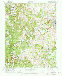 1962 Corydon West1964 Print · USGSHarrison County's rolling hills and deep river bends are captured here in the early sixties, centered on the historic seat of Corydon. Genealogists can trace family names and local landmarks like Perseverance Chapel, Jordan Cem, and the White Cloud settlement.5 unique versions available
 - 1966 Map of Corydon East, 1968 Print
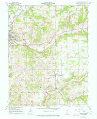 1966 Corydon East1968 Print · USGSHarrison County's rural townships and the historic seat of Corydon are captured here in the mid-1960s during a period of steady community growth. Trace family lineages through numerous local landmarks like Cedar Hill Cem, St Peters Ch, and the isolated Kings Cave.5 unique versions available
End of results
Showing maps 1-2 of 2
Top cities near Corydon
- Louisville historical maps
- Georgetown historical maps
- Brandenburg historical maps
- Marengo historical maps
- Palmyra historical maps
- Lanesville historical maps
See more
Top neighborhoods of Corydon
Frequently asked questions
- What are the different types of historical maps available for Corydon?
- What is the oldest map of Corydon?
- Where can I purchase historical maps of Corydon for my home or office?
- Where can I download high-res historical maps of Corydon?
- Are there historical topographic maps available for Corydon?
- Is there historical aerial imagery available for Corydon?
- Where are historical maps of Corydon sourced from?