1980s Maps of Elizabeth, Indiana
Explore 4 historic maps of Elizabeth from the 1980s. These maps offer a rare glimpse into what life looked like during the 1980s — showing old roads, neighborhoods, homes, and landmarks that have changed or disappeared over time.
Whether you're researching your family's past, planning a metal detecting trip, or studying how Elizabeth's landscape evolved across the 1980s, these high-resolution maps are a powerful tool for exploring the history of this region.
- Focus on a specific era: All maps on this page are from the 1980s, giving you a focused view of this time period.
- See what’s changed: Compare century-old streets, trails, and buildings to today's modern landscape using overlays and satellite layers.
- Research with precision: Use these maps for genealogy, historical research, land use analysis, or educational projects.
- View, download, or print: Maps are fully viewable online in high resolution, and can be downloaded or printed for your own records.
Start exploring Elizabeth's history through authentic maps from the 1980s. This is your window into the past.
Elizabeth, IN maps
(4)- 1981 Map of Kosmosdale
 1981 Kosmosdale1981 Print · USGSThe Ohio River corridor south of Louisville in the early eighties shows a landscape of suburban expansion meeting heavy river-industry. Researchers can trace family roots at De Pauw Cem, locate the former site of Watson Lane Sch, or explore the rail networks of the Illinois Central Gulf.3 unique versions available
 - 1982 Map of Lanesville
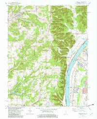 1982 Lanesville1982 Print · USGSHarrison County and the Ohio River shoreline are captured here in the early 1980s as rural crossroads and riverside settlements thrived. Family historians can trace local roots at Lanesville Cem, Lottick Corner, and St Johns Ch.2 unique versions available
 - 1985 Map of Lanesville, 1993 Print
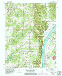 1985 Lanesville1993 Print · USGSThe Indiana bluffs and Kentucky riverbank are captured here during the mid-1980s, showcasing the transition from upland ridges to the industrial river corridor. Genealogists can trace family landmarks like Lanesville Cem, Heistand Cem, and the parish at St Johns Ch.
 - 1986 Map of Louisville
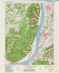
 1986 Louisville1986 Print · USGSMid-1980s Louisville and southern Indiana are shown here during a decade of significant suburban growth and infrastructure development. Researchers can trace the layout of Cave Hill Cemetery, the expansion of Standiford Field, and industrial sites like the Indiana Army Ammunition Plant.2 unique versions available
End of results
Showing maps 1-4 of 4
Top cities near Elizabeth
- Louisville historical maps
- Jeffersonville historical maps
- New Albany historical maps
- Clarksville historical maps
- Shively historical maps
- Shepherdsville historical maps
See more
Frequently asked questions
- What are the different types of historical maps available for Elizabeth?
- What is the oldest map of Elizabeth?
- Where can I purchase historical maps of Elizabeth for my home or office?
- Where can I download high-res historical maps of Elizabeth?
- Are there historical topographic maps available for Elizabeth?
- Is there historical aerial imagery available for Elizabeth?
- Where are historical maps of Elizabeth sourced from?