1950s Maps of Elizabeth, Indiana
Explore 6 historic maps of Elizabeth from the 1950s. These maps offer a rare glimpse into what life looked like during the 1950s — showing old roads, neighborhoods, homes, and landmarks that have changed or disappeared over time.
Whether you're researching your family's past, planning a metal detecting trip, or studying how Elizabeth's landscape evolved across the 1950s, these high-resolution maps are a powerful tool for exploring the history of this region.
- Focus on a specific era: All maps on this page are from the 1950s, giving you a focused view of this time period.
- See what’s changed: Compare century-old streets, trails, and buildings to today's modern landscape using overlays and satellite layers.
- Research with precision: Use these maps for genealogy, historical research, land use analysis, or educational projects.
- View, download, or print: Maps are fully viewable online in high resolution, and can be downloaded or printed for your own records.
Start exploring Elizabeth's history through authentic maps from the 1950s. This is your window into the past.
Elizabeth, IN maps
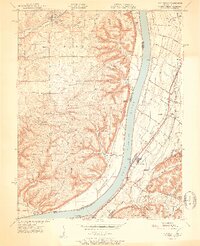
(6)- 1950 Map of Kosmosdale, 1959 Print
 1950 Kosmosdale1959 Print · USGSGreater Louisville and the Ohio River valley are captured here at mid-century, showing the city's industrial south side meeting rural river towns. Genealogists and historians can trace family locations through Lanesville Cem, the Waverly Hills Sanatorium, and Churchill Downs.
 - 1951 Map of Kosmosdale
 1951 Kosmosdale1951 Print · USGSThe Ohio River valley south of Louisville was a busy corridor of rail and road commerce in the early fifties. Genealogists and historians can trace local landmarks like Kosmosdale Sch, Mill Creek Cem, and the boundaries of the Fort Knox Military Reservation.2 unique versions available
 - 1951 Map of Lanesville
 1951 Lanesville1951 Print · USGSHarrison County and the Ohio River valley appear here in the early fifties, showing a rural landscape of ridge-top farms and river landings. Genealogists can trace family names through sites like Shoemaker Cem, Lottick Corner, and Seven Springs Sch.2 unique versions available
 - 1955 Map of Kosmosdale, 1956 Print
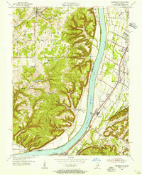 1955 Kosmosdale1956 Print · USGSThe river valley south of Louisville comes alive in the mid-fifties, showing the vital corridors of the Illinois Central and Dixie Highway. Genealogists and historians can trace family locations near Bethany, Meadow Lawn, and the rural Elizabeth Ch.
 - 1955 Map of Lanesville, 1956 Print
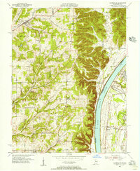 1955 Lanesville1956 Print · USGSHarrison County's river bluffs and rural townships are captured here in the mid-fifties, showing the rugged Indiana shoreline across from Kentucky. Researchers can trace ancestral sites at Lottick Corner, Hopewell Cem, and the old Locust Point PO.
 - 1956 Map of Louisville, 1971 Print
 1956 Louisville1971 Print · USGSThe Ohio River valley and the Kentucky Bluegrass are captured here during a period of rapid mid-century growth and industrial activity. Genealogists and historians can trace rail-centered towns and military land use at Fort Knox and the Jefferson Proving Ground.2 unique versions available
End of results
Showing maps 1-6 of 6
Top cities near Elizabeth
- Louisville historical maps
- Jeffersonville historical maps
- New Albany historical maps
- Clarksville historical maps
- Shively historical maps
- Shepherdsville historical maps
See more
Frequently asked questions
- What are the different types of historical maps available for Elizabeth?
- What is the oldest map of Elizabeth?
- Where can I purchase historical maps of Elizabeth for my home or office?
- Where can I download high-res historical maps of Elizabeth?
- Are there historical topographic maps available for Elizabeth?
- Is there historical aerial imagery available for Elizabeth?
- Where are historical maps of Elizabeth sourced from?