1990s Maps of Jasper County, Indiana
Explore 7 historic maps of Jasper County from the 1990s. These maps offer a rare glimpse into what life looked like during the 1990s — showing old roads, neighborhoods, homes, and landmarks that have changed or disappeared over time.
Whether you're researching your family's past, planning a metal detecting trip, or studying how Jasper County's landscape evolved across the 1990s, these high-resolution maps are a powerful tool for exploring the history of this region.
- Focus on a specific era: All maps on this page are from the 1990s, giving you a focused view of this time period.
- See what’s changed: Compare century-old streets, trails, and buildings to today's modern landscape using overlays and satellite layers.
- Research with precision: Use these maps for genealogy, historical research, land use analysis, or educational projects.
- View, download, or print: Maps are fully viewable online in high resolution, and can be downloaded or printed for your own records.
Start exploring Jasper County's history through authentic maps from the 1990s. This is your window into the past.
Jasper County, IN maps
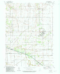
(7)- 1990 Map of Watseka, 1991 Print
 1990 Watseka1991 Print · USGSThe Illinois and Indiana borderlands are captured here in the early nineties, showing a landscape defined by prairie drainage and rail lines. You can trace family roots through settlements like L'Erable and Raub or locate landmarks such as Saint Josephs College.
 - 1991 Map of Kankakee
 1991 Kankakee1991 Print · USGSThe Illinois-Indiana borderlands come into focus during the early nineties, centered on the growing Kankakee valley and its sprawling drainage systems. Trace the rail-and-river economy through landmarks like the Wilton Railroad Grade, the Manteno State Hospital, and the historic Old Pioneer Cem.
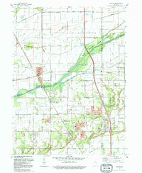
 - 1992 Map of Kouts
 1992 Kouts1992 Print · USGSNorthwestern Indiana's rural landscape is centered on Kouts and the Kankakee River in this early nineties survey. Researchers can trace historical routes and local markers like the Old Railroad Grade, Hopewell Cem, and Aylesworth.
 - 1992 Map of Shelby
 1992 Shelby1992 Print · USGSNorthwestern Indiana's river-and-rail corridor is captured here in the early nineties, showing the managed wetlands of the Kankakee valley. Genealogists and local historians can trace the foundations of Shelby, Roselawn, and the Monon RR line that once drove the local economy.
 - 1992 Map of Hebron
 1992 Hebron1992 Print · USGSPorter County in the early nineties shows a landscape of established rail towns and extensive drainage projects. Genealogists and local historians can trace the Old Railroad Grade through Hebron or locate family plots at Hebron Cem and Cornell Cem.
 - 1992 Map of Wheatfield
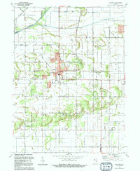
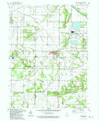 1992 Wheatfield1992 Print · USGSJasper County land and industry are captured here in the early nineties, showcasing the intersection of agricultural drainage and heavy power infrastructure. Researchers can trace family roots at Myers Cem or locate the site of the Townhall and the Kankakee Valley High Sch.
 - 1992 Map of De Motte
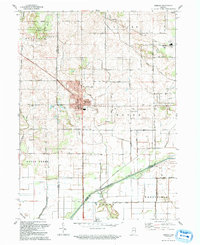
 1992 De Motte1992 Print · USGSJasper County is captured here in the early nineties, showing the organized drainage and agricultural growth surrounding DeMotte. Researchers can trace local lineage through several sites like the Holland Cem, Kniman, and the Cem of the Resurrection.
End of results
Showing maps 1-7 of 7
Top cities of Jasper County
- Rensselaer historical maps
- Remington historical maps
- Wheatfield historical maps
- Hanging Grove historical maps
Frequently asked questions
- What are the different types of historical maps available for Jasper County?
- What is the oldest map of Jasper County?
- Where can I purchase historical maps of Jasper County for my home or office?
- Where can I download high-res historical maps of Jasper County?
- Are there historical topographic maps available for Jasper County?
- Is there historical aerial imagery available for Jasper County?
- Where are historical maps of Jasper County sourced from?