1900s (20th Century) Maps of Rocklane, Indiana
Explore 9 historic maps of Rocklane from the 1900s (20th Century). These maps offer a rare glimpse into what life looked like during the 1900s — showing old roads, neighborhoods, homes, and landmarks that have changed or disappeared over time.
Whether you're researching your family's past, planning a metal detecting trip, or studying how Rocklane's landscape evolved across the 1900s, these high-resolution maps are a powerful tool for exploring the history of this region.
- Focus on a specific era: All maps on this page are from the 1900s, giving you a focused view of this time period.
- See what’s changed: Compare century-old streets, trails, and buildings to today's modern landscape using overlays and satellite layers.
- Research with precision: Use these maps for genealogy, historical research, land use analysis, or educational projects.
- View, download, or print: Maps are fully viewable online in high resolution, and can be downloaded or printed for your own records.
Start exploring Rocklane's history through authentic maps from the 1900s. This is your window into the past.
Rocklane, IN maps
(9)- 1953 Map of Greenwood, 1954 Print
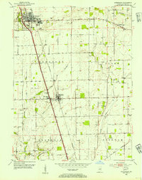 1953 Greenwood1954 Print · USGSGreenwood and Whiteland were growing rail-side communities in the early fifties, set against a backdrop of carefully managed Indiana farmland. Researchers can locate numerous family burial sites like Nolan Cem and Williams Cem, or trace the old path of the PENNSYLVANIA railroad.
 - 1953 Map of Indianapolis, 1965 Print
 1953 Indianapolis1965 Print · USGSCentral Indiana and the Illinois borderlands are captured in the mid-sixties, showing the growth of Indianapolis and its industrial rail corridors. Genealogists and historians can trace the development of outlying towns like Zionsville or Beech Grove and find landmarks such as Atterbury AAF and Turkey Run State Park.4 unique versions available
 - 1956 Map of Indianapolis
 1956 Indianapolis1956 Print · USGSCentral Indiana in the mid-fifties is captured during a period of industrial growth and military presence. Genealogists and historians can trace the rail networks of the New York Central or locate regional landmarks like Fort Benjamin Harrison and Camp Atterbury.
 - 1957 Map of Indianapolis
 1957 Indianapolis1957 Print · USGSCentral Indiana in the mid-fifties is captured here as a crossroads of major rail lines and nascent federal highways. Genealogists and historians can trace family-named ridges like Poplar Ridge or locate strategic sites like Camp Atterbury and Speedway.2 unique versions available
 - 1959 Map of Greenwood, 1960 Print
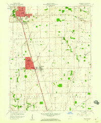 1959 Greenwood1960 Print · USGSJohnson County was undergoing a residential transformation in the late fifties as suburban developments reached south of Greenwood. Genealogists can trace family names and locations through several rural burial grounds like Rocklane Cem and landmarks like Donalds Knoll.
 - 1962 Map of Indianapolis
 1962 Indianapolis1962 Print · USGSCentral Indiana and the Illinois borderlands are captured here in the early sixties, showing the region's dense rail networks and growing urban centers. Genealogists and historians can locate family-named landmarks and institutions like Crown Hill Cem, Indiana University, and the Indianapolis Motor Speedway.
 - 1973 Map of Greenwood, 1975 Print
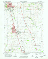 1973 Greenwood1975 Print · USGSCentral Indiana's suburban corridor is captured here in the early seventies, showing the growth between Greenwood and Franklin. Genealogists can trace family landmarks like Nolan Cem and Pleasant View Ch among the evolving rail lines.3 unique versions available
 - 1986 Map of Indianapolis
 1986 Indianapolis1986 Print · USGSThe Indiana capital and its surrounding counties are captured here in the mid-1980s, showcasing the height of its orbital highway development and suburban growth. Researchers can trace the legacy of the Fort Benjamin Harrison Military Reservation, follow the Conrail lines, or locate family roots in Beech Grove, Greencastle, and Zionsville.2 unique versions available
 - 1992 Map of Greenwood, 1995 Print
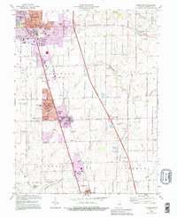 1992 Greenwood1995 Print · USGSJohnson County experiences significant suburban growth in the early nineties as residential developments expand along the rail corridor. Researchers can trace local lineage through Greenwood Cemetery, Hurricane Cem, and historic country congregations like Mount Zion Ch.
End of results
Showing maps 1-9 of 9
Top cities near Rocklane
- Indianapolis historical maps
- Greenwood historical maps
- Lawrence historical maps
- Franklin historical maps
- Shelbyville historical maps
- Greenfield historical maps
See more
Frequently asked questions
- What are the different types of historical maps available for Rocklane?
- What is the oldest map of Rocklane?
- Where can I purchase historical maps of Rocklane for my home or office?
- Where can I download high-res historical maps of Rocklane?
- Are there historical topographic maps available for Rocklane?
- Is there historical aerial imagery available for Rocklane?
- Where are historical maps of Rocklane sourced from?