1940s Maps of Edwardsport, Indiana
Explore 2 historic maps of Edwardsport from the 1940s. These maps offer a rare glimpse into what life looked like during the 1940s — showing old roads, neighborhoods, homes, and landmarks that have changed or disappeared over time.
Whether you're researching your family's past, planning a metal detecting trip, or studying how Edwardsport's landscape evolved across the 1940s, these high-resolution maps are a powerful tool for exploring the history of this region.
- Focus on a specific era: All maps on this page are from the 1940s, giving you a focused view of this time period.
- See what’s changed: Compare century-old streets, trails, and buildings to today's modern landscape using overlays and satellite layers.
- Research with precision: Use these maps for genealogy, historical research, land use analysis, or educational projects.
- View, download, or print: Maps are fully viewable online in high resolution, and can be downloaded or printed for your own records.
Start exploring Edwardsport's history through authentic maps from the 1940s. This is your window into the past.
Edwardsport, IN maps
(2)- 1943 Map of Bicknell
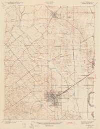 1943 Bicknell1943 Print · USGSIn the early 1940s, this portion of Knox County was a hub of coal production and rail activity centered on the growing city of Bicknell. Genealogists and historians can locate numerous family burial sites like Walker Cem and trace the local mining economy through labels like Sunshine Mine and Panhandle Mine.2 unique versions available
 - 1943 Map of Plainville
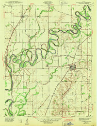 1943 Plainville1943 Print · USGSDaviess and Knox Counties appear here in the early 1940s, where the winding loops of the White River dominate the agricultural landscape. Genealogists and local historians can trace family locations near Plainville, Westphalia, or the historic Vincennes Tract boundary.2 unique versions available
End of results
Showing maps 1-2 of 2
Top cities near Edwardsport
- Vincennes historical maps
- Washington historical maps
- Linton historical maps
- Bicknell historical maps
- Busseron historical maps
- Lyons historical maps
See more
Frequently asked questions
- What are the different types of historical maps available for Edwardsport?
- What is the oldest map of Edwardsport?
- Where can I purchase historical maps of Edwardsport for my home or office?
- Where can I download high-res historical maps of Edwardsport?
- Are there historical topographic maps available for Edwardsport?
- Is there historical aerial imagery available for Edwardsport?
- Where are historical maps of Edwardsport sourced from?