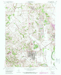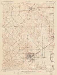
1943 Map of Bicknell
USGS Topo · Published 1943About this map
Coal extraction and heavy industry dominate this landscape in the early 1940s, with a dense cluster of shafts and workings surrounding the city of Bicknell. The town's economic life is centered on the Pennsylvania railroad and a ring of operations including the North Side Mine, Sunshine Mine, and Lynn Mine. To the east, the White River forms a natural boundary between Knox and Daviess counties, while the interior terrain is marked by a complex system of drainage such as Wells Ditch and Brocksmith and Wolfe Ditch. Local life is anchored by family and community institutions, from the Bethel Ch and Maria Creek Ch to numerous burial grounds including Walker Cem and Chambers Cem. Small settlements like Freelandville and Johnstown dot the northern and southern reaches, while Scudder Hill provides one of the few prominent natural elevations in a landscape otherwise reshaped by extensive strip mining.
Find a feature on this map
40 named features on this map. Tap any name to fly to it.
Don’t see what you’re looking for? This feature index may not catch every label — zoom into the map to look around manually.
Map Details
Editions of this 1943 Bicknell Map
2 editions found
Historical Maps of Bicknell Through Time
7 maps found