
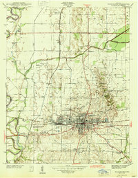
1944 Map of Washington
USGS Topo · Published 1944About this map
Washington serves as a significant rail and agricultural hub in Daviess County during the mid-1940s, situated at the junction of the Baltimore and Ohio and New York Central railroads. The town's grid is well-established, featuring local institutions like Longfellow Sch and Jefferson Sch, alongside industry-specific landmarks such as the Washington Water Works. To the west, the White River forms a natural boundary, meandering past the US Dept of Agriculture Experiment Station and the settlement of Maysville. The surrounding landscape is characterized by its agricultural drainage system, including Hawes Ditch and Killion Ditch, which support the fertile lowlands. Local history is preserved in numerous family and community burial grounds like Hawkins Cem and Oak Grove Cem, while the northern portion of the map highlights the distinctively named North Fork Thousand Acre Woods.
Find a feature on this map
47 named features on this map. Tap any name to fly to it.
Don’t see what you’re looking for? This feature index may not catch every label — zoom into the map to look around manually.
Map Details
Editions of this 1944 Washington Map
2 editions found
Other maps of this area

1943 · Bicknell
USGS Topo · 1:24,000

1943 · Plainville
USGS Topo · 1:24,000

1943 · Epsom
USGS Topo · 1:24,000

1944 · Montgomery
USGS Topo · 1:24,000

1944 · Glendale
USGS Topo · 1:24,000

1944 · Monroe City
USGS Topo · 1:24,000

1944 · Wheatland
USGS Topo · 1:24,000

1945 · Sandy Hook
USGS Topo · 1:24,000

1956 · Vincennes
USGS Topo · 1:250,000

1957 · Vincennes
USGS Topo · 1:250,000