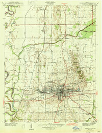
1944 Map of Washington
USGS Topo · Published 1944About this map
Washington serves as the industrial and transportation anchor for this part of Daviess County, centered at the intersection of the Baltimore and Ohio and New York Central railroads. The town’s grid is flanked by the Washington Water Works and a Golf Course, while surrounding smaller communities like Maysville and South Washington reveal the region's early 20th-century expansion. Along the western edge, the White River meanders through bottomlands, creating oxbows such as Swan Pond and Blue Hole Pond.
Find a feature on this map
41 named features on this map. Tap any name to fly to it.
Don’t see what you’re looking for? This feature index may not catch every label — zoom into the map to look around manually.
Map Details
Editions of this 1944 Washington Map
2 editions found
Other maps of this area

1943 · Bicknell
USGS Topo · 1:24,000

1943 · Plainville
USGS Topo · 1:24,000

1943 · Epsom
USGS Topo · 1:24,000

1944 · Montgomery
USGS Topo · 1:24,000

1944 · Glendale
USGS Topo · 1:24,000

1944 · Washington
USGS Topo · 1:24,000

1944 · Monroe City
USGS Topo · 1:24,000

1944 · Wheatland
USGS Topo · 1:24,000

1945 · Sandy Hook
USGS Topo · 1:24,000

1956 · Vincennes
USGS Topo · 1:250,000