
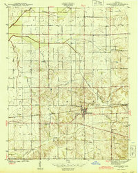
1944 Map of Montgomery
USGS Topo · Published 1944About this map
The Baltimore and Ohio railroad corridor anchors this 1940s landscape, serving as the industrial spine for the town of Montgomery and the neighboring hamlet of Black Oak. This survey reveals a high density of rural social infrastructure, with several district schools including School No 1, Parsons Sch, and St Michael Sch serving the surrounding agricultural townships. The drainage of the land is carefully managed through a series of engineered waterworks like Swamp Ditch and Oberts Ditch, which feed into the larger branches of North Fork Prairie Creek and South Fork Prairie Creek. Prominent local landmarks such as Antioch Ch, Bethany Ch, and St Peters Cem provide specific points of interest for genealogists tracing family locations across the Barr and Bogard township lines during the mid-twentieth century.
Find a feature on this map
27 named features on this map. Tap any name to fly to it.
Don’t see what you’re looking for? This feature index may not catch every label — zoom into the map to look around manually.
Map Details
Editions of this 1944 Montgomery Map
2 editions found
Other maps of this area

1943 · Plainville
USGS Topo · 1:24,000

1943 · Epsom
USGS Topo · 1:24,000

1944 · Glendale
USGS Topo · 1:24,000

1944 · Washington
USGS Topo · 1:24,000

1945 · Sandy Hook
USGS Topo · 1:24,000

1950 · Odon
USGS Topo · 1:24,000

1956 · Alfordsville
USGS Topo · 1:24,000

1956 · Loogootee
USGS Topo · 1:24,000

1956 · Vincennes
USGS Topo · 1:250,000

1957 · Vincennes
USGS Topo · 1:250,000