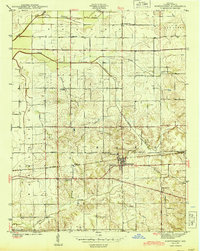
1944 Map of Montgomery
USGS Topo · Published 1944About this map
Montgomery and the adjacent community of Cannelburg serve as the primary hubs of activity in this 1944 survey of Daviess County. The Baltimore and Ohio Railroad runs east-west through the center of the sheet, paralleling the Washington Baltimore and Bedford Road, a major thoroughfare reflecting the era's connectivity between regional centers. The landscape is defined by the convergence of the North Fork and South Fork Prairie Creek, which are fed by numerous man-made drainage systems like Bethell Ditch and Swamp Ditch, indicating the historical efforts to manage the wetlands of Barr and Bogard townships for agriculture.
Find a feature on this map
27 named features on this map. Tap any name to fly to it.
Don’t see what you’re looking for? This feature index may not catch every label — zoom into the map to look around manually.
Map Details
Editions of this 1944 Montgomery Map
2 editions found
Other maps of this area

1943 · Plainville
USGS Topo · 1:24,000

1943 · Epsom
USGS Topo · 1:24,000

1944 · Montgomery
USGS Topo · 1:24,000

1944 · Glendale
USGS Topo · 1:24,000

1944 · Washington
USGS Topo · 1:24,000

1945 · Sandy Hook
USGS Topo · 1:24,000

1950 · Odon
USGS Topo · 1:24,000

1956 · Alfordsville
USGS Topo · 1:24,000

1956 · Loogootee
USGS Topo · 1:24,000

1956 · Vincennes
USGS Topo · 1:250,000