
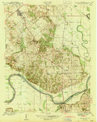
1944 Map of Monroe City
USGS Topo · Published 1944About this map
Monroe City serves as the primary hub in this mid-century portrait of Knox County, Indiana, where the landscape is defined by the sweeping curves of the White River. The topography transitions from the low-lying bottomlands of Sevenmile Bend to the more elevated, dissected terrain of the interior, notably around The Bluffs. This era reveals a community deeply rooted in its local institutions, evidenced by a dense network of rural sanctuaries such as Hamline Chapel, Wilson Creek Church, and Reels Chapel.
Find a feature on this map
31 named features on this map. Tap any name to fly to it.
Don’t see what you’re looking for? This feature index may not catch every label — zoom into the map to look around manually.
Map Details
Editions of this 1944 Monroe City Map
2 editions found
Other maps of this area

1902 · Ditney
USGS Topo · 1:125,000

1903 · Velpen
USGS Topo · 1:62,500

1903 · Petersburg
USGS Topo · 1:62,500

1942 · Fritchton
USGS Topo · 1:24,000

1944 · Fritchton
USGS Topo · 1:24,000

1944 · Washington
USGS Topo · 1:24,000

1944 · Wheatland
USGS Topo · 1:24,000

1944 · Iona
USGS Topo · 1:24,000

1945 · Sandy Hook
USGS Topo · 1:24,000

1956 · Vincennes
USGS Topo · 1:250,000