
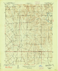
1944 Map of Bucktown
USGS Topo · Published 1944About this map
Bucktown and the surrounding townships of Haddon and Jefferson reveal a mid-century landscape defined by rural crossroads and the expanding footprint of the coal industry. Surveyed just before the United States entered the war, this area shows a dense network of family cemeteries such as Skidmore Cem and Benefiel Cem, alongside community centers like Bethlehem Ch and Indian Prairie Ch. The eastern edge of the map highlights the shift in land use with several large Strip Mine operations near Pleasantville. The North Boundary Vincennes Tract cuts across the southern portion of the sheet, marking a significant historical land survey line between Sullivan and Knox counties. Waterways like Maria Creek and Marsh Creek drain the undulating terrain, while a Fire Tower stands as a sentinel over the wooded ridges near the eastern border.
Find a feature on this map
28 named features on this map. Tap any name to fly to it.
Don’t see what you’re looking for? This feature index may not catch every label — zoom into the map to look around manually.
Map Details
Editions of this 1944 Bucktown Map
2 editions found
Other maps of this area

1940 · Linton
USGS Topo · 1:24,000

1943 · Carlisle
USGS Topo · 1:24,000

1943 · Oaktown
USGS Topo · 1:24,000

1943 · Sandborn
USGS Topo · 1:24,000

1943 · Bicknell
USGS Topo · 1:24,000

1943 · Plainville
USGS Topo · 1:24,000

1943 · Sullivan
USGS Topo · 1:24,000

1943 · Dugger
USGS Topo · 1:24,000

1947 · Linton
USGS Topo · 1:24,000
1952 · Dugger
USGS Topo · 1:24,000