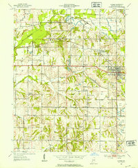
1952 Map of Dugger
USGS Topo · Published 1953About this map
Extensive surface mining operations dominate the landscape of eastern Sullivan County during the mid-20th century. Numerous Strip Mine sites and a prominent Mine Dump define the terrain, reflecting the heavy industrial character of the era. The town of Dugger serves as the primary hub, where the Illinois Central and Pennsylvania railroads intersect to facilitate the region's coal transit.
Find a feature on this map
36 named features on this map. Tap any name to fly to it.
Don’t see what you’re looking for? This feature index may not catch every label — zoom into the map to look around manually.
Map Details
Editions of this 1952 Dugger Map
This is the sole edition of this map. No revisions or reprints were ever made.
Other maps of this area

1940 · Linton
USGS Topo · 1:24,000

1940 · Jasonville
USGS Topo · 1:24,000

1942 · Shelburn
USGS Topo · 1:24,000

1943 · Hymera
USGS Topo · 1:24,000

1943 · Carlisle
USGS Topo · 1:24,000

1943 · Sandborn
USGS Topo · 1:24,000

1943 · Sullivan
USGS Topo · 1:24,000

1943 · Dugger
USGS Topo · 1:24,000

1944 · Bucktown
USGS Topo · 1:24,000

1947 · Linton
USGS Topo · 1:24,000