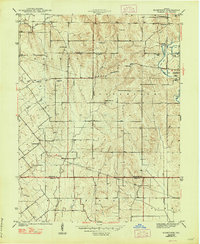
1944 Map of Bucktown
USGS Topo · Published 1948About this map
Bucktown and Pleasantville anchor this mid-century survey of the rural landscape along the Sullivan Co Knox Co line. The terrain is defined by the winding course of Maria Creek and its many tributaries, including Marsh Creek and Bear Run. This map captures a community organized around its spiritual and ancestral centers, documented by a high density of country churches and family burial grounds. Researchers can trace the locations of Mt Zion Ch, Indian Prairie Ch, and Bethany Ch, alongside family-named sites like Benefiel Cem and Skidmore Cem. To the east, the emergence of the Strip Mine industry near the Fire Tower suggests the shift toward resource extraction that would reshape the local economy and topography, while the Vincennes Tract Road provides a link to older overland travel patterns through Jefferson and Haddon townships.
Find a feature on this map
29 named features on this map. Tap any name to fly to it.
Don’t see what you’re looking for? This feature index may not catch every label — zoom into the map to look around manually.
Map Details
Editions of this 1944 Bucktown Map
2 editions found
Other maps of this area

1940 · Linton
USGS Topo · 1:24,000

1943 · Carlisle
USGS Topo · 1:24,000

1943 · Oaktown
USGS Topo · 1:24,000

1943 · Sandborn
USGS Topo · 1:24,000

1943 · Bicknell
USGS Topo · 1:24,000

1943 · Plainville
USGS Topo · 1:24,000

1943 · Sullivan
USGS Topo · 1:24,000

1943 · Dugger
USGS Topo · 1:24,000

1944 · Bucktown
USGS Topo · 1:24,000

1947 · Linton
USGS Topo · 1:24,000