1960s Maps of LaPorte County, Indiana
Explore 11 historic maps of LaPorte County from the 1960s. These maps offer a rare glimpse into what life looked like during the 1960s — showing old roads, neighborhoods, homes, and landmarks that have changed or disappeared over time.
Whether you're researching your family's past, planning a metal detecting trip, or studying how LaPorte County's landscape evolved across the 1960s, these high-resolution maps are a powerful tool for exploring the history of this region.
- Focus on a specific era: All maps on this page are from the 1960s, giving you a focused view of this time period.
- See what’s changed: Compare century-old streets, trails, and buildings to today's modern landscape using overlays and satellite layers.
- Research with precision: Use these maps for genealogy, historical research, land use analysis, or educational projects.
- View, download, or print: Maps are fully viewable online in high resolution, and can be downloaded or printed for your own records.
Start exploring LaPorte County's history through authentic maps from the 1960s. This is your window into the past.
LaPorte County, IN maps
(11)- 1961 Map of La Porte West, 1964 Print
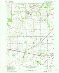
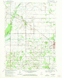
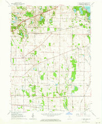 1961 La Porte West1964 Print · USGSLa Porte County at the start of the sixties shows a landscape shaped by early treaty lines and a dense network of major railroads. Genealogists and local historians can trace rural school districts and old settlements such as Door Village, Pinhook, and Pinola.
 - 1962 Map of Westville, 1964 Print
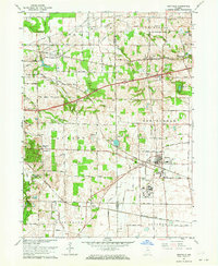 1962 Westville1964 Print · USGSWestville and the surrounding townships are shown at a peak of rail and institutional development during the early sixties. Genealogists and local historians can trace family roots through the Quakerdom Cem, the Eight-Square Ch, and old stops at Burdick and Coburg.
 - 1962 Map of Michigan City West, 1964 Print
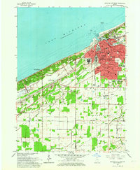 1962 Michigan City West1964 Print · USGSCoastal life and heavy industry meet along the Indiana dunes in the early sixties. Genealogists and rail historians can trace the paths of the South Shore Line, local schools like Barker Jr High, and the grounds of the State Prison.
 - 1969 Map of Lydick, 1971 Print
 1969 Lydick1971 Print · USGSSt. Joseph County's industrial and rail corridor is captured here in the late sixties, showing the development between South Bend and the county line. Researchers can trace historic settlements like New Carlisle and Crumstown or locate the St Stanislaus Ch and Bendix Woods Park.2 unique versions available
 - 1969 Map of Kingsford Heights, 1971 Print
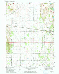
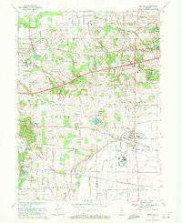
 1969 Kingsford Heights1971 Print · USGSLaPorte County at the close of the 1960s shows a landscape of engineered farmland and growing crossroads. Researchers can trace family sites near Township Cem, the unique street plan of Kingsford Heights, and the rail lines of the Penn Central.2 unique versions available
 - 1969 Map of Michigan City West, 1971 Print
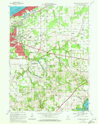
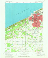 1969 Michigan City West1971 Print · USGSThe Indiana shoreline of Lake Michigan comes into focus here during the late sixties, showing the industrial and residential growth of MICHIGAN CITY. Researchers can trace the massive State Prison, the lakefront Washington Park, and the early layout of Beverly Shores.4 unique versions available
 - 1969 Map of Westville, 1971 Print
 1969 Westville1971 Print · USGSNear the Porter and La Porte county line in the early seventies, this area shows a landscape defined by major rail lines and rising institutions. Genealogists and local historians can trace family plots at Quakerdom Cem or locate the sprawling Beatty Memorial Hospital and the nearby State Prison Farm.2 unique versions available
 - 1969 Map of La Porte West, 1971 Print
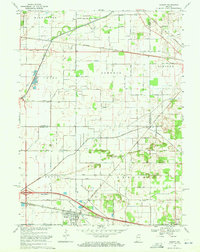
 1969 La Porte West1971 Print · USGSThe rural prairie west of La Porte comes alive in the late sixties, showing a landscape defined by glacial lakes and a bustling rail network. Genealogists and historians can locate the Township Sch, Pinhook Cem, and the historic settlement at Door Village.3 unique versions available
 - 1969 Map of Knox West, 1971 Print
 1969 Knox West1971 Print · USGSStarke County at the end of the 1960s is a landscape of extensive drainage systems and railroad junctions. Trace the rural history of Brems and Knox, or locate local landmarks like Round Lake Ch, Hepner Cem, and the Starke County Airport.2 unique versions available
 - 1969 Map of Hamlet, 1971 Print
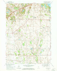
 1969 Hamlet1971 Print · USGSStarke and La Porte counties are captured here in the late sixties as the rail-centered economy of Hamlet remained the focal point of the local landscape. Genealogists and researchers can trace the Penn Central lines, the historic Yellowstone Trail, and landmarks like the Township Sch and Grovertown.2 unique versions available
 - 1969 Map of Michigan City East, 1971 Print
 1969 Michigan City East1971 Print · USGSLaPorte County, Indiana, is captured at the end of the sixties as Michigan City expanded into the surrounding townships. Researchers can trace historic rail lines like the Norfolk and Western and locate rural landmarks such as Sharp Cem or the State Prison Farm.2 unique versions available
End of results
Showing maps 1-11 of 11
Top cities of LaPorte County
- Michigan City historical maps
- La Porte historical maps
- Westville historical maps
- Springfield historical maps
- Kankakee historical maps
- Trail Creek historical maps
See more
Frequently asked questions
- What are the different types of historical maps available for LaPorte County?
- What is the oldest map of LaPorte County?
- Where can I purchase historical maps of LaPorte County for my home or office?
- Where can I download high-res historical maps of LaPorte County?
- Are there historical topographic maps available for LaPorte County?
- Is there historical aerial imagery available for LaPorte County?
- Where are historical maps of LaPorte County sourced from?