1930s Maps of Lawrence County, Indiana
Explore 3 historic maps of Lawrence County from the 1930s. These maps offer a rare glimpse into what life looked like during the 1930s — showing old roads, neighborhoods, homes, and landmarks that have changed or disappeared over time.
Whether you're researching your family's past, planning a metal detecting trip, or studying how Lawrence County's landscape evolved across the 1930s, these high-resolution maps are a powerful tool for exploring the history of this region.
- Focus on a specific era: All maps on this page are from the 1930s, giving you a focused view of this time period.
- See what’s changed: Compare century-old streets, trails, and buildings to today's modern landscape using overlays and satellite layers.
- Research with precision: Use these maps for genealogy, historical research, land use analysis, or educational projects.
- View, download, or print: Maps are fully viewable online in high resolution, and can be downloaded or printed for your own records.
Start exploring Lawrence County's history through authentic maps from the 1930s. This is your window into the past.
Lawrence County, IN maps
(3)- 1934 Map of Bedford
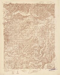 1934 Bedford1934 Print · USGSLawrence County's limestone district and the winding White River valley are detailed here during the mid-1930s. Genealogists and researchers can trace local families through many rural landmarks, including Sherril Cem, Leesville, and the Peerless Quarry.2 unique versions available
 - 1935 Map of Oolitic
 1935 Oolitic1935 Print · USGSLawrence and Greene Counties are captured in the mid-1930s during a period of heavy limestone production and rural transition. Local historians can trace family roots through numerous country landmarks like Popcorn Church, Williams Bridge, and the Dark Hollow stone works.6 unique versions available
 - 1937 Map of Bedford
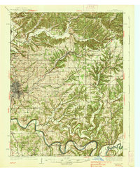 1937 Bedford1937 Print · USGSLawrence County limestone country is seen here in the late 1930s, defined by its massive quarries and river-valley railroads. Genealogists can trace family landmarks and rural life at the County Farm, Leesville, and the United Brethren Ch.2 unique versions available
End of results
Showing maps 1-3 of 3
Top cities of Lawrence County
- Bedford historical maps
- Mitchell historical maps
- Guthrie historical maps
- Oolitic historical maps
- Bono historical maps
Frequently asked questions
- What are the different types of historical maps available for Lawrence County?
- What is the oldest map of Lawrence County?
- Where can I purchase historical maps of Lawrence County for my home or office?
- Where can I download high-res historical maps of Lawrence County?
- Are there historical topographic maps available for Lawrence County?
- Is there historical aerial imagery available for Lawrence County?
- Where are historical maps of Lawrence County sourced from?