Old Maps of Lawrence County, Indiana for Metal Detecting
Plan your next treasure hunt with 98 historic maps of Lawrence County. Find old homesites, ghost towns, trails, and gathering spots that may be lost to time — perfect for identifying promising metal detecting locations.
- Locate forgotten sites: Uncover places like long-lost settlements, abandoned rail lines, or gathering spots.
- Plan better hunts: Use map overlays combined with LiDAR or satellite views to narrow in on historically rich areas.
- Made for detectorists: Thousands of hobbyists use these maps to discover relics, coins, and hidden history.
Use these historic maps to boost your research and find new opportunities beneath the surface of Lawrence County.
Lawrence County, IN maps
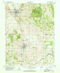
(98)- 1934 Map of Bedford
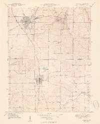
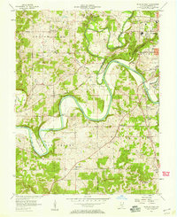
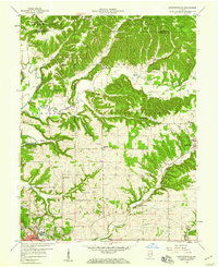
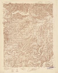 1934 Bedford1934 Print · USGSLawrence County's limestone district and the winding White River valley are detailed here during the mid-1930s. Genealogists and researchers can trace local families through many rural landmarks, including Sherril Cem, Leesville, and the Peerless Quarry.2 unique versions available
 - 1935 Map of Oolitic
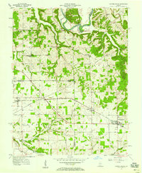
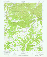
 1935 Oolitic1935 Print · USGSLawrence and Greene Counties are captured in the mid-1930s during a period of heavy limestone production and rural transition. Local historians can trace family roots through numerous country landmarks like Popcorn Church, Williams Bridge, and the Dark Hollow stone works.6 unique versions available
 - 1937 Map of Bedford
 1937 Bedford1937 Print · USGSLawrence County limestone country is seen here in the late 1930s, defined by its massive quarries and river-valley railroads. Genealogists can trace family landmarks and rural life at the County Farm, Leesville, and the United Brethren Ch.2 unique versions available
 - 1942 Map of Oolitic
 1942 Oolitic1942 Print · USGSLawrence County limestone country is seen here in the mid-1930s, documenting the early stone industry and rail networks. Genealogists can trace family landmarks like Popcorn Cem, Bethel Ch, and industrial sites such as Patton Hill Quarry.2 unique versions available
 - 1948 Map of Huron, 1960 Print
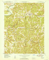
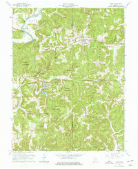
 1948 Huron1960 Print · USGSMartin County in the late 1940s is characterized by its deep forest tracts and the busy rail line through the village of Huron. Researchers can trace early rural life through surviving landmarks like Scarlet Chapel, Wiesbach Sch, and the Baltimore and Ohio railroad.
 - 1949 Map of Georgia, 1962 Print
 1949 Georgia1962 Print · USGSThe rural borders of Lawrence and Orange Counties come alive in this post-war survey of a landscape shaped by the Baltimore and Ohio railroad. Local researchers can trace family roots through the many country churches and schools like Bonds Chapel, Georgia Ch, and the Hindostan Sch.
 - 1950 Map of Mitchell
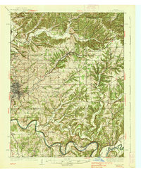
 1950 Mitchell1950 Print · USGSMitchell and Orleans sit at a critical railroad junction in southern Indiana during the mid-twentieth century. Researchers can trace the karst landscape of Spring Mill State Park or locate family roots near Liberty Ch and Lawrenceport Cem.2 unique versions available
 - 1950 Map of Huron
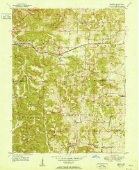
 1950 Huron1950 Print · USGSSouthern Indiana's timbered hills and rail corridors are captured here in the mid-twentieth century. Genealogists and hikers can trace the Baltimore and Ohio line past Willow Tunnel or find the remote Acre Cem and Wiesbach Sch.
 - 1951 Map of Georgia
 1951 Georgia1951 Print · USGSSouthern Indiana's rural landscape is captured here in the early fifties, where the Baltimore and Ohio rail line links the settlements of Georgia and Moorestown. Genealogists and local historians can trace family roots through numerous landmarks, from the Hindostan Sch to the Georgia Cem and Bonds Chapel.
 - 1956 Map of Vincennes, 1967 Print
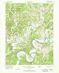
 1956 Vincennes1967 Print · USGSSouthern Indiana and the Illinois borderlands are captured here in the mid-fifties, showing the region's dense network of river towns and rail lines. Researchers can trace historic river crossings along the Wabash River or locate landmarks like Wyandotte Cave and Lincoln State Park.4 unique versions available
 - 1957 Map of Vincennes
 1957 Vincennes1957 Print · USGSSouthwest Indiana and the Illinois borderlands come alive in the late 1950s, a period of heavy rail traffic and expanding state forests. Genealogists and historians can trace the riverfronts and rail lines of Vincennes, New Harmony, and the vast Crane Naval Ammunition Depot.
 - 1957 Map of Oolitic, 1958 Print
 1957 Oolitic1958 Print · USGSLawrence County limestone country is captured here in the late fifties, showing the industrial pulse of the quarries and rail lines. Researchers can trace the MONON railroad through Oolitic and find local landmarks like Beard Sch and the State Fish Hatchery.2 unique versions available
 - 1957 Map of Bedford West, 1958 Print
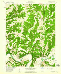
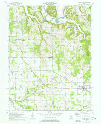
 1957 Bedford West1958 Print · USGSLawrence County's river-carved hills and limestone country are captured here during the late fifties as rural life and industry converged. Genealogists can trace family roots through numerous sites like Bryantsville, Eureka, and the Thomson Cem along the East Fork White River.2 unique versions available
 - 1957 Map of Campbellsburg, 1958 Print
 1957 Campbellsburg1958 Print · USGSSouthern Indiana farming and rail life are captured here in the late fifties, showing the Monon line threading through small towns. Genealogists can locate family landmarks like Stonington Ch, Fairview Sch, and the Freedom Cem.2 unique versions available
 - 1957 Map of Williams, 1958 Print
 1957 Williams1958 Print · USGSThe East Fork White River winds through Lawrence County in the mid-1950s, a landscape defined by timbered ridges and rural rail lines. Trace family roots at Silverville or locate landmarks like Williams Bridge and the Mountain Spring Cem.2 unique versions available
 - 1957 Map of Owensburg, 1958 Print
 1957 Owensburg1958 Print · USGSSouthern Indiana's rural landscape is captured here in the late fifties, where the hill country of Greene County meets major federal installations. Researchers can locate family cemeteries like Lowder Cem, rural landmarks such as Bridge Ch, and the northern edge of the U S Naval Reservation Crane Ammunition Depot.2 unique versions available
 - 1958 Map of Vincennes
 1958 Vincennes1958 Print · USGSSouthern Indiana and the Illinois borderlands are captured during a mid-century period of heavy rail traffic and military activity. Researchers can trace the sprawling bounds of the Crane Naval Ammunition Depot or locate historic settlements like New Harmony and French Lick.2 unique versions available
 - 1958 Map of Bartlettsville, 1959 Print
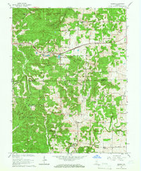
 1958 Bartlettsville1959 Print · USGSLawrence and Monroe counties are shown in the late fifties as timbered ridges and creek valleys define the rural landscape. Researchers can locate family landmarks like Hillenburg Cem, the rail siding at Erie, and several country churches like Ramsey Ridge Ch.2 unique versions available
 - 1958 Map of Norman, 1959 Print
 1958 Norman1959 Print · USGSLawrence County in the late fifties shows a landscape of ridge-top settlements and national forest land. Genealogists and local historians can locate the small communities of Norman, Zelma, and Yellowstone, and trace the winding course of Salt Creek.4 unique versions available
 - 1958 Map of Tunnelton, 1960 Print
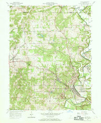
 1958 Tunnelton1960 Print · USGSLawrence County at the end of the fifties reveals a landscape shaped by the East Fork White River and the busy Baltimore and Ohio rail line. Genealogists and local historians can trace the foundations of Tunnelton, Fort Ritner, and remote landmarks like Devils Backbone.2 unique versions available
 - 1958 Map of Bedford East, 1960 Print
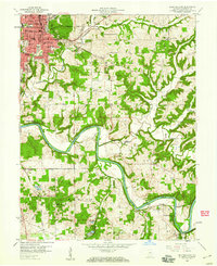 1958 Bedford East1960 Print · USGSLawrence County at the end of the 1950s shows the bustling hub of Bedford surrounded by the winding waters of the White River. Genealogists and local historians can trace rural family roots through numerous landmarks like Beech Grove Cem, Rabbitville, and Leatherwood Ch.2 unique versions available
 - 1960 Map of Mitchell, 1961 Print
 1960 Mitchell1961 Print · USGSSouthern Indiana at the dawn of the sixties shows a landscape shaped by karst geology and early transit lines. Genealogists can trace family roots through Freedom Cem and Union Chapel, or explore the historic Spring Mill Village.5 unique versions available
 - 1965 Map of Georgia, 1966 Print
 1965 Georgia1966 Print · USGSLawrence and Orange Counties are shown in the mid-1960s as the rail-driven town of Georgia anchors the northern valleys. Researchers can trace historic church sites like Bonds Chapel and Mt Horeb Ch or locate family burial grounds including Isom Cem and Hall Cem.2 unique versions available
 - 1965 Map of Huron, 1966 Print
 1965 Huron1966 Print · USGSThe hill country of Martin and Lawrence Counties is captured here in the mid-1960s, showing the intersection of heavy rail and deep timberlands. You can trace early family roots through Huron Cem and Baxter Cem or locate the engineering of the Willow Tunnel.3 unique versions available
 - 1970 Map of Campbellsburg, 1972 Print
 1970 Campbellsburg1972 Print · USGSSouthern Indiana rail and river life converge here during the early seventies, centered on the MONON line. Researchers can trace the layout of small settlements like Saltillo and Campbellsburg or locate rural landmarks like Fishing Creek Chapel and Freedom Cem.2 unique versions available
Showing maps 1-25 of 98
Top cities of Lawrence County
- Bedford historical maps
- Mitchell historical maps
- Guthrie historical maps
- Oolitic historical maps
- Bono historical maps
Frequently asked questions
- What are the different types of historical maps available for Lawrence County?
- What is the oldest map of Lawrence County?
- Where can I purchase historical maps of Lawrence County for my home or office?
- Where can I download high-res historical maps of Lawrence County?
- Are there historical topographic maps available for Lawrence County?
- Is there historical aerial imagery available for Lawrence County?
- Where are historical maps of Lawrence County sourced from?