1900s (20th Century) Maps of Anderson, Indiana
Explore 9 historic maps of Anderson from the 1900s (20th Century). These maps offer a rare glimpse into what life looked like during the 1900s — showing old roads, neighborhoods, homes, and landmarks that have changed or disappeared over time.
Whether you're researching your family's past, planning a metal detecting trip, or studying how Anderson's landscape evolved across the 1900s, these high-resolution maps are a powerful tool for exploring the history of this region.
- Focus on a specific era: All maps on this page are from the 1900s, giving you a focused view of this time period.
- See what’s changed: Compare century-old streets, trails, and buildings to today's modern landscape using overlays and satellite layers.
- Research with precision: Use these maps for genealogy, historical research, land use analysis, or educational projects.
- View, download, or print: Maps are fully viewable online in high resolution, and can be downloaded or printed for your own records.
Start exploring Anderson's history through authentic maps from the 1900s. This is your window into the past.
Anderson, IN maps
(9)- 1952 Map of Anderson, 1954 Print
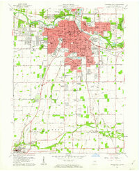
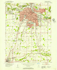 1952 Anderson1954 Print · USGSAnderson and the southern reaches of Madison County are captured in the early fifties during a period of significant postwar growth. Researchers can trace historic family plots at Harmeson Cem, locate the old Sun Valley Speedway, and explore the rail networks of the NY C RR and Pennsylvania RR.
 - 1953 Map of Lapel, 1954 Print
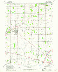
 1953 Lapel1954 Print · USGSMadison County in the early fifties shows a landscape of growing towns and established family homesteads. Genealogists and historians can locate markers like Old Woodward Cem, the Limestone Quarry in Lapel, and the rural Old German Ch.2 unique versions available
 - 1953 Map of Muncie, 1966 Print
 1953 Muncie1966 Print · USGSIndiana and Ohio borderlands thrive in the early fifties, showing a landscape defined by manufacturing cities and an intensive railroad network. Genealogists can trace family roots across the Indiana-Ohio line through Muncie, Celina, and Portland via the Pennsylvania railroad.5 unique versions available
 - 1956 Map of Muncie
 1956 Muncie1956 Print · USGSEastern Indiana and western Ohio are shown at a peak of rail-driven industry in the mid-fifties. Genealogists and rail historians can trace the paths of the Pennsylvania RR through Muncie or locate landmarks like Lake Saint Marys (Grand Lake Reservoir) and Frances Slocum State Forest.
 - 1960 Map of Middletown, 1961 Print
 1960 Middletown1961 Print · USGSThe rural landscapes of Madison, Delaware, and Henry counties are captured here at the dawn of the sixties. Genealogists can trace family names at Bronnenberg Cem or Painter Cem, and locate rural landmarks like the Allen-Bethel Ch and Valley Grove Sch.4 unique versions available
 - 1960 Map of Anderson North, 1961 Print
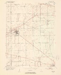
 1960 Anderson North1961 Print · USGSMadison County in the early sixties shows the suburban growth of Anderson and Alexandria amidst a landscape of rural schools and family chapels. Genealogists can trace property near Wesley Chapel, Donahue Cem, and the village of Prosperity.5 unique versions available
 - 1961 Map of Anderson South, 1962 Print
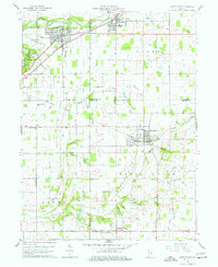
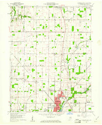
 1961 Anderson South1962 Print · USGSMadison County at the dawn of the 1960s shows the suburban expansion of Anderson alongside long-established rural villages. Trace family roots and local industry through features like Grovelawn Cem, Mounds State Park, and the tracks of the Pennsylvania RR.4 unique versions available
 - 1967 Map of Lapel, 1968 Print
 1967 Lapel1968 Print · USGSWestern Madison County in the late sixties reveals a landscape of growing towns and established rail lines. Genealogists and local historians can trace the foundations of Lapel and Pendleton, or locate rural landmarks like Old Woodward Cemetery and the Old German Church.2 unique versions available
 - 1986 Map of Muncie
 1986 Muncie1986 Print · USGSEast Central Indiana was a hub of manufacturing and higher education in the mid-eighties. Genealogists and historians can trace the streets of Muncie, locate rural Cem sites, and explore landmarks like Mounds State Park and Taylor Univ.3 unique versions available
End of results
Showing maps 1-9 of 9
Top cities near Anderson
- Fishers historical maps
- Noblesville historical maps
- Elwood historical maps
- Alexandria historical maps
- Yorktown historical maps
- Pendleton historical maps
See more
Top neighborhoods of Anderson
- Irondale historical maps
- Meadowbrook historical maps
- Western Village historical maps
- Crestlawn historical maps
- Eastern Heights historical maps
- Elmhurst historical maps
See more
Frequently asked questions
- What are the different types of historical maps available for Anderson?
- What is the oldest map of Anderson?
- Where can I purchase historical maps of Anderson for my home or office?
- Where can I download high-res historical maps of Anderson?
- Are there historical topographic maps available for Anderson?
- Is there historical aerial imagery available for Anderson?
- Where are historical maps of Anderson sourced from?