1940s Maps of Indianapolis, Indiana
Explore 4 historic maps of Indianapolis from the 1940s. These maps offer a rare glimpse into what life looked like during the 1940s — showing old roads, neighborhoods, homes, and landmarks that have changed or disappeared over time.
Whether you're researching your family's past, planning a metal detecting trip, or studying how Indianapolis's landscape evolved across the 1940s, these high-resolution maps are a powerful tool for exploring the history of this region.
- Focus on a specific era: All maps on this page are from the 1940s, giving you a focused view of this time period.
- See what’s changed: Compare century-old streets, trails, and buildings to today's modern landscape using overlays and satellite layers.
- Research with precision: Use these maps for genealogy, historical research, land use analysis, or educational projects.
- View, download, or print: Maps are fully viewable online in high resolution, and can be downloaded or printed for your own records.
Start exploring Indianapolis's history through authentic maps from the 1940s. This is your window into the past.
Indianapolis, IN maps
(4)- 1948 Map of Indianapolis East
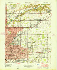 1948 Indianapolis East1948 Print · USGSNortheast Marion County is documented here during the post-war industrial boom, showing the expansion of Indianapolis toward Lawrence. Researchers can locate vanished landmarks like Brightwood Airport, the Naval Ordnance Plant, and numerous local sites like Browning Sch.2 unique versions available
 - 1948 Map of Maywood
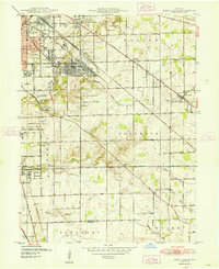
 1948 Maywood1948 Print · USGSThe southern suburbs of Indianapolis are captured here in the post-war era as industrial centers and new neighborhoods expand toward the county line. Genealogists and historians can trace the foundations of Mars Hill, explore the campus of Indiana Central College, or locate family sites at Holy Cross Cem.2 unique versions available
 - 1948 Map of Beech Grove
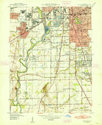
 1948 Beech Grove1948 Print · USGSSoutheast Marion County is captured here in the late 1940s as its rail-towns and suburban fringes expanded. Researchers can trace the massive Indianapolis Union RR yards or locate family roots near New Bethel, Southport, and New Crown Cem.
 - 1948 Map of Indianapolis West
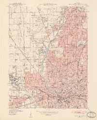 1948 Indianapolis West1948 Print · USGSIndianapolis and its western suburbs thrive in the late 1940s, revealing a landscape of bustling industry, grand civic centers, and emerging neighborhoods. Trace the early footprints of the Indianapolis Motor Speedway, the historic Crown Hill Cemetery, and the busy Hoosier Airport.2 unique versions available
End of results
Showing maps 1-4 of 4
Top cities near Indianapolis
- Carmel historical maps
- Fishers historical maps
- Noblesville historical maps
- Greenwood historical maps
- Westfield historical maps
- Lawrence historical maps
See more
Top neighborhoods of Indianapolis
- Belle Arbor historical maps
- Hunters Crossing historical maps
- Indian Creek Estates historical maps
- Julietta historical maps
- Lakeside historical maps
- Drexel Gardens historical maps
See more
Frequently asked questions
- What are the different types of historical maps available for Indianapolis?
- What is the oldest map of Indianapolis?
- Where can I purchase historical maps of Indianapolis for my home or office?
- Where can I download high-res historical maps of Indianapolis?
- Are there historical topographic maps available for Indianapolis?
- Is there historical aerial imagery available for Indianapolis?
- Where are historical maps of Indianapolis sourced from?