1900s (20th Century) Maps of Homecroft, Indianapolis
Explore 13 historic maps of Homecroft from the 1900s (20th Century). These maps offer a rare glimpse into what life looked like during the 1900s — showing old roads, neighborhoods, homes, and landmarks that have changed or disappeared over time.
Whether you're researching your family's past, planning a metal detecting trip, or studying how Homecroft's landscape evolved across the 1900s, these high-resolution maps are a powerful tool for exploring the history of this region.
- Focus on a specific era: All maps on this page are from the 1900s, giving you a focused view of this time period.
- See what’s changed: Compare century-old streets, trails, and buildings to today's modern landscape using overlays and satellite layers.
- Research with precision: Use these maps for genealogy, historical research, land use analysis, or educational projects.
- View, download, or print: Maps are fully viewable online in high resolution, and can be downloaded or printed for your own records.
Start exploring Homecroft's history through authentic maps from the 1900s. This is your window into the past.
Homecroft, Indianapolis maps
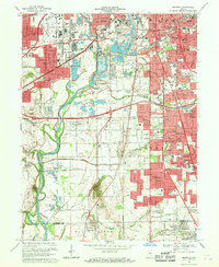
(13)- 1948 Map of Maywood
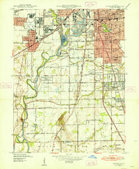 1948 Maywood1948 Print · USGSThe southern suburbs of Indianapolis are captured here in the post-war era as industrial centers and new neighborhoods expand toward the county line. Genealogists and historians can trace the foundations of Mars Hill, explore the campus of Indiana Central College, or locate family sites at Holy Cross Cem.2 unique versions available
 - 1948 Map of Beech Grove
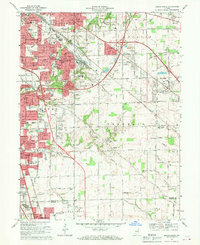
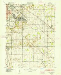 1948 Beech Grove1948 Print · USGSSoutheast Marion County is captured here in the late 1940s as its rail-towns and suburban fringes expanded. Researchers can trace the massive Indianapolis Union RR yards or locate family roots near New Bethel, Southport, and New Crown Cem.
 - 1953 Map of Indianapolis, 1965 Print
 1953 Indianapolis1965 Print · USGSCentral Indiana and the Illinois borderlands are captured in the mid-sixties, showing the growth of Indianapolis and its industrial rail corridors. Genealogists and historians can trace the development of outlying towns like Zionsville or Beech Grove and find landmarks such as Atterbury AAF and Turkey Run State Park.4 unique versions available
 - 1956 Map of Indianapolis
 1956 Indianapolis1956 Print · USGSCentral Indiana in the mid-fifties is captured during a period of industrial growth and military presence. Genealogists and historians can trace the rail networks of the New York Central or locate regional landmarks like Fort Benjamin Harrison and Camp Atterbury.
 - 1957 Map of Indianapolis
 1957 Indianapolis1957 Print · USGSCentral Indiana in the mid-fifties is captured here as a crossroads of major rail lines and nascent federal highways. Genealogists and historians can trace family-named ridges like Poplar Ridge or locate strategic sites like Camp Atterbury and Speedway.2 unique versions available
 - 1959 Map of Beech Grove, 1961 Print
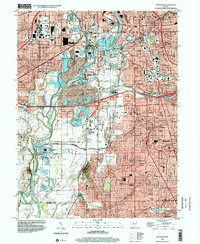
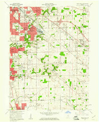 1959 Beech Grove1961 Print · USGSSoutheastern Indianapolis and the rail-centric hub of Beech Grove are caught in a period of mid-century suburban expansion. Genealogists and local historians can trace the foundations of neighborhoods like Twin Brooks and identify historic landmarks like Maple Hill Ch & Cem and Wheatcraft Airport.
 - 1959 Map of Maywood, 1961 Print
 1959 Maywood1961 Print · USGSThe southern suburbs of Indianapolis and northern Johnson County are captured here during a period of rapid post-war growth. Researchers can trace family history through numerous landmarks like Indiana Central College, Union Stockyards, and Southport High Sch.
 - 1962 Map of Indianapolis
 1962 Indianapolis1962 Print · USGSCentral Indiana and the Illinois borderlands are captured here in the early sixties, showing the region's dense rail networks and growing urban centers. Genealogists and historians can locate family-named landmarks and institutions like Crown Hill Cem, Indiana University, and the Indianapolis Motor Speedway.
 - 1967 Map of Maywood, 1969 Print
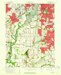
 1967 Maywood1969 Print · USGSMarion County's southern industrial and residential sprawl is captured here in the late sixties as the city pushed toward the Johnson County line. Researchers can trace family roots at Indiana Central College, locate the old Union Stockyards, or find records at Calvary Cemetery.3 unique versions available
 - 1967 Map of Beech Grove, 1969 Print
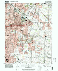
 1967 Beech Grove1969 Print · USGSSoutheastern Indianapolis and the industrial hub of Beech Grove are captured here during a period of rapid suburban growth. Genealogists and local historians can trace the development of Southport and New Bethel or locate schools and landmarks like Skyway Airport and the Penn Central rail lines.4 unique versions available
 - 1986 Map of Indianapolis
 1986 Indianapolis1986 Print · USGSThe Indiana capital and its surrounding counties are captured here in the mid-1980s, showcasing the height of its orbital highway development and suburban growth. Researchers can trace the legacy of the Fort Benjamin Harrison Military Reservation, follow the Conrail lines, or locate family roots in Beech Grove, Greencastle, and Zionsville.2 unique versions available
 - 1998 Map of Maywood, 2002 Print
 1998 Maywood2002 Print · USGSThe southern suburbs of Indianapolis and the White River valley are captured here in the late 1990s as residential growth meets legacy industry. Researchers can locate family roots at Hebrew Cemetery or trace the early footprint of Indiana Central College and Stout Field.
 - 1998 Map of Beech Grove, 2002 Print
 1998 Beech Grove2002 Print · USGSSoutheast of Indianapolis in the late nineties, this area reveals a landscape of maturing suburbs and industrial rail corridors. Genealogists can trace family sites near New Crown Cemetery, Wanamaker, and St Johns Cem & Ch.
End of results
Showing maps 1-13 of 13
Top cities near Homecroft
- Indianapolis historical maps
- Greenwood historical maps
- Lawrence historical maps
- Plainfield historical maps
- Franklin historical maps
- Brownsburg historical maps
See more
Frequently asked questions
- What are the different types of historical maps available for Homecroft?
- What is the oldest map of Homecroft?
- Where can I purchase historical maps of Homecroft for my home or office?
- Where can I download high-res historical maps of Homecroft?
- Are there historical topographic maps available for Homecroft?
- Is there historical aerial imagery available for Homecroft?
- Where are historical maps of Homecroft sourced from?