1960s Maps of Argos, Indiana
Explore 2 historic maps of Argos from the 1960s. These maps offer a rare glimpse into what life looked like during the 1960s — showing old roads, neighborhoods, homes, and landmarks that have changed or disappeared over time.
Whether you're researching your family's past, planning a metal detecting trip, or studying how Argos's landscape evolved across the 1960s, these high-resolution maps are a powerful tool for exploring the history of this region.
- Focus on a specific era: All maps on this page are from the 1960s, giving you a focused view of this time period.
- See what’s changed: Compare century-old streets, trails, and buildings to today's modern landscape using overlays and satellite layers.
- Research with precision: Use these maps for genealogy, historical research, land use analysis, or educational projects.
- View, download, or print: Maps are fully viewable online in high resolution, and can be downloaded or printed for your own records.
Start exploring Argos's history through authentic maps from the 1960s. This is your window into the past.
Argos, IN maps
(2)- 1962 Map of Argos, 1964 Print
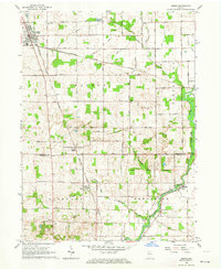 1962 Argos1964 Print · USGSNorthern Indiana's rural landscape is captured here in the early sixties, showing the transition between the agricultural plains and the winding Tippecanoe River. Genealogists can trace local roots through landmarks like the Walnut Ch, McGrew Cem, and the historic Old Indian Treaty Boundary.3 unique versions available
 - 1962 Map of Rutland, 1964 Print
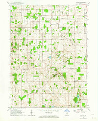 1962 Rutland1964 Print · USGSMarshall and Fulton County farmlands are captured here in the early sixties, split by the historic Old Indian Treaty Bdy. Genealogists can locate family-named landmarks and rural hubs like Poplar Grove Ch, Richland Center, and Rutland.2 unique versions available
End of results
Showing maps 1-2 of 2
Top cities near Argos
- Plymouth historical maps
- Nappanee historical maps
- Rochester historical maps
- Bremen historical maps
- Walnut historical maps
- Walkerton historical maps
See more
Frequently asked questions
- What are the different types of historical maps available for Argos?
- What is the oldest map of Argos?
- Where can I purchase historical maps of Argos for my home or office?
- Where can I download high-res historical maps of Argos?
- Are there historical topographic maps available for Argos?
- Is there historical aerial imagery available for Argos?
- Where are historical maps of Argos sourced from?