1960s Maps of Peru, Indiana
Explore 3 historic maps of Peru from the 1960s. These maps offer a rare glimpse into what life looked like during the 1960s — showing old roads, neighborhoods, homes, and landmarks that have changed or disappeared over time.
Whether you're researching your family's past, planning a metal detecting trip, or studying how Peru's landscape evolved across the 1960s, these high-resolution maps are a powerful tool for exploring the history of this region.
- Focus on a specific era: All maps on this page are from the 1960s, giving you a focused view of this time period.
- See what’s changed: Compare century-old streets, trails, and buildings to today's modern landscape using overlays and satellite layers.
- Research with precision: Use these maps for genealogy, historical research, land use analysis, or educational projects.
- View, download, or print: Maps are fully viewable online in high resolution, and can be downloaded or printed for your own records.
Start exploring Peru's history through authentic maps from the 1960s. This is your window into the past.
Peru, IN maps
(3)- 1960 Map of Peru, 1962 Print
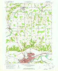 1960 Peru1962 Print · USGSMiami County in the early sixties was a hub of river-and-rail activity centered on the convergence of the Wabash and Mississinewa. Genealogists can trace family names at Westlawn Cem or Mount Hope Cemetery and locate rural landmarks like Victory Sch and the hamlet of Courter.4 unique versions available
 - 1963 Map of Twelve Mile, 1964 Print
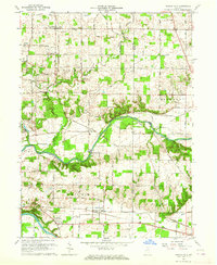 1963 Twelve Mile1964 Print · USGSCass County agriculture and river life converged in the early sixties as railroads like the Chesapeake and Ohio linked rural communities. Genealogists can trace family roots through Mt Carmel Ch, Bethlehem Ch, and the Eel River Chapel Cem.4 unique versions available
 - 1963 Map of Bunker Hill, 1964 Print
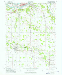 1963 Bunker Hill1964 Print · USGSMiami County at the start of the 1960s shows a landscape of busy rail junctions and river valleys. Genealogists and local historians can trace family locations near Bunker Hill, the County Farm, or rural sites like New Hope Cemetery.4 unique versions available
End of results
Showing maps 1-3 of 3
Top cities near Peru
- Logansport historical maps
- Wabash historical maps
- Galveston historical maps
- Bunker Hill historical maps
- Mexico historical maps
- Denver historical maps
See more
Top neighborhoods of Peru
- Ridgeview historical maps
- Park View Heights historical maps
- Oakdale historical maps
- South Peru historical maps
Frequently asked questions
- What are the different types of historical maps available for Peru?
- What is the oldest map of Peru?
- Where can I purchase historical maps of Peru for my home or office?
- Where can I download high-res historical maps of Peru?
- Are there historical topographic maps available for Peru?
- Is there historical aerial imagery available for Peru?
- Where are historical maps of Peru sourced from?