1990s Maps of Monroe County, Indiana
Explore 11 historic maps of Monroe County from the 1990s. These maps offer a rare glimpse into what life looked like during the 1990s — showing old roads, neighborhoods, homes, and landmarks that have changed or disappeared over time.
Whether you're researching your family's past, planning a metal detecting trip, or studying how Monroe County's landscape evolved across the 1990s, these high-resolution maps are a powerful tool for exploring the history of this region.
- Focus on a specific era: All maps on this page are from the 1990s, giving you a focused view of this time period.
- See what’s changed: Compare century-old streets, trails, and buildings to today's modern landscape using overlays and satellite layers.
- Research with precision: Use these maps for genealogy, historical research, land use analysis, or educational projects.
- View, download, or print: Maps are fully viewable online in high resolution, and can be downloaded or printed for your own records.
Start exploring Monroe County's history through authentic maps from the 1990s. This is your window into the past.
Monroe County, IN maps
(11)- 1990 Map of Bedford, 1991 Print
 1990 Bedford1991 Print · USGSSouthern Indiana in the early nineties reveals a complex landscape of military reservations, resort towns, and heavy industry. Genealogists and historians can trace family sites like Old Union Cem and Trinity Springs or locate the limestone quarries surrounding Oolitic.
 - 1993 Map of Elkinsville, 1996 Print
 1993 Elkinsville1996 Print · USGSBrown County's rugged ridges and the waters of the Middle Fork Salt Creek are captured here in the early 1990s. Researchers can locate the Terrill Cem, the Hickory Ridge Lookout, and the small community of Elkinsville.
 - 1998 Map of Whitehall, 2002 Print
 1998 Whitehall2002 Print · USGSThe hill country west of Bloomington is captured in the late 1990s as it spans three county lines. Genealogists and local historians can trace legacy sites from the Owen County Home Cemetery to the small settlements of Whitehall and Hendricksville.
 - 1998 Map of Gosport, 2002 Print
 1998 Gosport2002 Print · USGSIndiana stone country and the river valley are captured here in the late nineties, showing the industrial and rural character of the region. Researchers can trace the limestone industry through numerous quarries near Stinesville or locate family sites at Gosport Cem and Shiloh Ch.
 - 1998 Map of Morgantown, 2002 Print
 1998 Morgantown2002 Print · USGSMorgan and Brown counties are captured here in the late nineties, showing a landscape defined by the deep timber of Yellowwood State Forest. Genealogists and hikers can trace the Old Railroad Grade or locate historic landmarks like the Covered Bridge and Williams Cem.
 - 1998 Map of Hindustan, 2002 Print
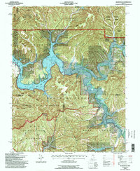
 1998 Hindustan2002 Print · USGSMonroe and Morgan counties are shown at the turn of the millennium as the terrain rises from Lake Lemon into deep forest ridges. Genealogists can trace family names through sites like Stepp Cem and the Dolan Ridge Mission or locate the historic Old Indian Treaty Boundary.
 - 1998 Map of Modesto, 2002 Print
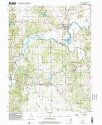
 1998 Modesto2002 Print · USGSThe rural borderlands of Morgan and Monroe counties are captured here in the late twentieth century, showing the balance between agriculture and conservation. Researchers can trace family history through numerous landmarks like New Salem Cem, Union Ch, and the small settlement of Modesto.
 - 1998 Map of Belmont, 2003 Print
 1998 Belmont2003 Print · USGSBrown County's rugged ridges and forest reserves are captured here at the close of the twentieth century. Genealogists and local historians can trace family land near Belmont, find the West Tollhouse, or locate rural landmarks like Hickory Hill Cem and Oak Grove Ch.
 - 1998 Map of Bloomington, 2003 Print
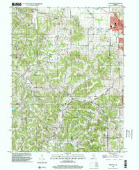
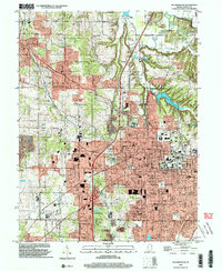 1998 Bloomington2003 Print · USGSMonroe County enters the late twentieth century with its academic and urban core in full view. Genealogists and local historians can trace family locations through Rose Hill Cemetery, identify old school sites like Dyer Jr High Sch, and locate the historic Hunter Switch rail point.
 - 1998 Map of Unionville, 2003 Print
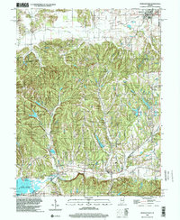
 1998 Unionville2003 Print · USGSMonroe County east of Bloomington is shown here in the late twentieth century as suburban growth met the deep hollows of the Morgan-Monroe State Forest. Genealogists can trace family landmarks like Knight Ridge Cemetery and the historic Mount Gilead Church near the Indiana Railroad.
 - 1999 Map of Clear Creek, 2001 Print
 1999 Clear Creek2001 Print · USGSMonroe County's limestone country and the headwaters of the Monroe Reservoir are shown here at the turn of the millennium. Researchers can trace the industrial footprint of local Quarries and locate historic community sites like Walkers Chapel and Clover Hill Cem.
End of results
Showing maps 1-11 of 11
Top cities of Monroe County
- Bloomington historical maps
- Ellettsville historical maps
- Clear Creek historical maps
- Stinesville historical maps
Frequently asked questions
- What are the different types of historical maps available for Monroe County?
- What is the oldest map of Monroe County?
- Where can I purchase historical maps of Monroe County for my home or office?
- Where can I download high-res historical maps of Monroe County?
- Are there historical topographic maps available for Monroe County?
- Is there historical aerial imagery available for Monroe County?
- Where are historical maps of Monroe County sourced from?