1960s Maps of Handy, Indiana
Explore 2 historic maps of Handy from the 1960s. These maps offer a rare glimpse into what life looked like during the 1960s — showing old roads, neighborhoods, homes, and landmarks that have changed or disappeared over time.
Whether you're researching your family's past, planning a metal detecting trip, or studying how Handy's landscape evolved across the 1960s, these high-resolution maps are a powerful tool for exploring the history of this region.
- Focus on a specific era: All maps on this page are from the 1960s, giving you a focused view of this time period.
- See what’s changed: Compare century-old streets, trails, and buildings to today's modern landscape using overlays and satellite layers.
- Research with precision: Use these maps for genealogy, historical research, land use analysis, or educational projects.
- View, download, or print: Maps are fully viewable online in high resolution, and can be downloaded or printed for your own records.
Start exploring Handy's history through authentic maps from the 1960s. This is your window into the past.
Handy, IN maps
(2)- 1962 Map of Indianapolis
 1962 Indianapolis1962 Print · USGSCentral Indiana and the Illinois borderlands are captured here in the early sixties, showing the region's dense rail networks and growing urban centers. Genealogists and historians can locate family-named landmarks and institutions like Crown Hill Cem, Indiana University, and the Indianapolis Motor Speedway.
 - 1966 Map of Allens Creek, 1968 Print
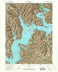 1966 Allens Creek1968 Print · USGSMonroe County terrain underwent a massive transformation in the mid-sixties as the newly formed Monroe Reservoir reshaped the valley. You can trace the submerged paths of Salt Creek and find enduring local landmarks like Shiloh Temple, Siscoe, and the Dutch Ridge Lookout Tower.6 unique versions available
End of results
Showing maps 1-2 of 2
Top cities near Handy
- Bloomington historical maps
- Bedford historical maps
- Ellettsville historical maps
- Clear Creek historical maps
- Guthrie historical maps
- Oolitic historical maps
See more
Frequently asked questions
- What are the different types of historical maps available for Handy?
- What is the oldest map of Handy?
- Where can I purchase historical maps of Handy for my home or office?
- Where can I download high-res historical maps of Handy?
- Are there historical topographic maps available for Handy?
- Is there historical aerial imagery available for Handy?
- Where are historical maps of Handy sourced from?