1960s Maps of Beverly Shores, Indiana
Explore 3 historic maps of Beverly Shores from the 1960s. These maps offer a rare glimpse into what life looked like during the 1960s — showing old roads, neighborhoods, homes, and landmarks that have changed or disappeared over time.
Whether you're researching your family's past, planning a metal detecting trip, or studying how Beverly Shores's landscape evolved across the 1960s, these high-resolution maps are a powerful tool for exploring the history of this region.
- Focus on a specific era: All maps on this page are from the 1960s, giving you a focused view of this time period.
- See what’s changed: Compare century-old streets, trails, and buildings to today's modern landscape using overlays and satellite layers.
- Research with precision: Use these maps for genealogy, historical research, land use analysis, or educational projects.
- View, download, or print: Maps are fully viewable online in high resolution, and can be downloaded or printed for your own records.
Start exploring Beverly Shores's history through authentic maps from the 1960s. This is your window into the past.
Beverly Shores, IN maps
(3)- 1962 Map of Michigan City West, 1964 Print
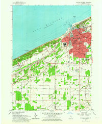 1962 Michigan City West1964 Print · USGSCoastal life and heavy industry meet along the Indiana dunes in the early sixties. Genealogists and rail historians can trace the paths of the South Shore Line, local schools like Barker Jr High, and the grounds of the State Prison.
 - 1968 Map of Dune Acres, 1970 Print
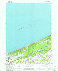 1968 Dune Acres1970 Print · USGSThe Indiana shoreline was undergoing a dramatic evolution in the late sixties as conservation efforts met industrial expansion. Trace family roots at Bailey Cem or explore the early boundaries of Beverly Shores and the peaks of Mt Tom.2 unique versions available
 - 1969 Map of Michigan City West, 1971 Print
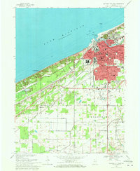 1969 Michigan City West1971 Print · USGSThe Indiana shoreline of Lake Michigan comes into focus here during the late sixties, showing the industrial and residential growth of MICHIGAN CITY. Researchers can trace the massive State Prison, the lakefront Washington Park, and the early layout of Beverly Shores.4 unique versions available
End of results
Showing maps 1-3 of 3
Top cities near Beverly Shores
- Portage historical maps
- Valparaiso historical maps
- Michigan City historical maps
- La Porte historical maps
- Chesterton historical maps
- Porter historical maps
See more
Frequently asked questions
- What are the different types of historical maps available for Beverly Shores?
- What is the oldest map of Beverly Shores?
- Where can I purchase historical maps of Beverly Shores for my home or office?
- Where can I download high-res historical maps of Beverly Shores?
- Are there historical topographic maps available for Beverly Shores?
- Is there historical aerial imagery available for Beverly Shores?
- Where are historical maps of Beverly Shores sourced from?