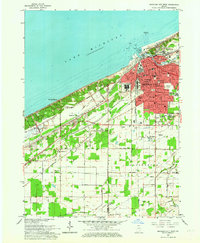
1962 Map of Michigan City West
USGS Topo · Published 1964About this map
Lake Michigan dominates the northwestern horizon of this 1962 survey, which documents the industrial and transportation infrastructure of northern Porter Co La Porte Co County. The urban center of Michigan City is shown in detail, featuring landmarks like the State Prison, the Filtration Plant, and a Coast Guard Station at the mouth of Trail Creek. A complex network of steel and steam defines the landscape, with the Chicago South Shore and South Bend Railroad and New York Central Railroad cutting paths through the dunes and marshland. To the west, the planned communities of Beverly Shores and the Town of Pines appear alongside early residential developments like Southwood and Edgewood. The map also captures several parochial institutions, including St Pauls Sch and St Stanislaus Sch, reflecting the deep-rooted community foundations of the era.
Find a feature on this map
59 named features on this map. Tap any name to fly to it.
Don’t see what you’re looking for? This feature index may not catch every label — zoom into the map to look around manually.
Map Details
Editions of this 1962 Michigan City West Map
This is the sole edition of this map. No revisions or reprints were ever made.
Other maps of this area

1934 · Porter
USGS Topo · 1:48,000

1940 · Porter
USGS Topo · 1:62,500

1953 · Westville
USGS Topo · 1:24,000

1953 · Chesterton
USGS Topo · 1:24,000

1953 · Dune Acres
USGS Topo · 1:24,000

1953 · Michigan City West
USGS Topo · 1:24,000

1953 · Chicago
USGS Topo · 1:250,000

1957 · Chicago
USGS Topo · 1:250,000

1958 · Michigan City East
USGS Topo · 1:24,000
1961 · La Porte West
USGS Topo · 1:24,000