1930s Maps of Blackhawk Beach, Indiana
Explore 1 historic maps of Blackhawk Beach from the 1930s. These maps offer a rare glimpse into what life looked like during the 1930s — showing old roads, neighborhoods, homes, and landmarks that have changed or disappeared over time.
Whether you're researching your family's past, planning a metal detecting trip, or studying how Blackhawk Beach's landscape evolved across the 1930s, these high-resolution maps are a powerful tool for exploring the history of this region.
- Focus on a specific era: All maps on this page are from the 1930s, giving you a focused view of this time period.
- See what’s changed: Compare century-old streets, trails, and buildings to today's modern landscape using overlays and satellite layers.
- Research with precision: Use these maps for genealogy, historical research, land use analysis, or educational projects.
- View, download, or print: Maps are fully viewable online in high resolution, and can be downloaded or printed for your own records.
Start exploring Blackhawk Beach's history through authentic maps from the 1930s. This is your window into the past.
Blackhawk Beach, IN maps
(1)- 1934 Map of Porter
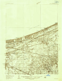 1934 Porter1934 Print · USGSThe Indiana shoreline of the mid-1930s is mapped here in detail, from the sands of Indiana Dunes State Park to the rail hubs of Chesterton. Trace local family history through sites like the Seven Dolors Shrine, Liberty Center Sch, and the Mc Cool Emergency Landing Field.
End of results
Showing maps 1-1 of 1
Top cities near Blackhawk Beach
- Gary historical maps
- Portage historical maps
- Valparaiso historical maps
- Michigan City historical maps
- Merrillville historical maps
- Hobart historical maps
See more
Frequently asked questions
- What are the different types of historical maps available for Blackhawk Beach?
- What is the oldest map of Blackhawk Beach?
- Where can I purchase historical maps of Blackhawk Beach for my home or office?
- Where can I download high-res historical maps of Blackhawk Beach?
- Are there historical topographic maps available for Blackhawk Beach?
- Is there historical aerial imagery available for Blackhawk Beach?
- Where are historical maps of Blackhawk Beach sourced from?