1940s Maps of Versailles, Indiana
Explore 2 historic maps of Versailles from the 1940s. These maps offer a rare glimpse into what life looked like during the 1940s — showing old roads, neighborhoods, homes, and landmarks that have changed or disappeared over time.
Whether you're researching your family's past, planning a metal detecting trip, or studying how Versailles's landscape evolved across the 1940s, these high-resolution maps are a powerful tool for exploring the history of this region.
- Focus on a specific era: All maps on this page are from the 1940s, giving you a focused view of this time period.
- See what’s changed: Compare century-old streets, trails, and buildings to today's modern landscape using overlays and satellite layers.
- Research with precision: Use these maps for genealogy, historical research, land use analysis, or educational projects.
- View, download, or print: Maps are fully viewable online in high resolution, and can be downloaded or printed for your own records.
Start exploring Versailles's history through authentic maps from the 1940s. This is your window into the past.
Versailles, IN maps
(2)- 1946 Map of Versailles
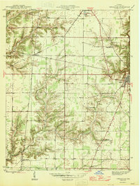 1946 Versailles1946 Print · USGSRipley County at the end of the Second World War shows a rural landscape of crossroads settlements and creek-side homesteads. Researchers can trace family roots through Otter Village Cem, the historic MICHIGAN ROAD, and schools like Tanglewood Ch.
 - 1946 Map of Milan
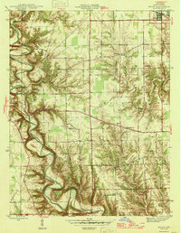 1946 Milan1946 Print · USGSRipley County in the mid-1940s is defined by the deep meanders of Laughery Creek and the burgeoning Versailles State Recreational Area. Researchers can locate several rural landmarks including the Fire Tower, Stringtown Sch, and family cemeteries like Wilson Cem.2 unique versions available
End of results
Showing maps 1-2 of 2
Top cities near Versailles
- Batesville historical maps
- Sparta historical maps
- Milan historical maps
- Osgood historical maps
- Pleasant historical maps
- Delaware historical maps
See more
Frequently asked questions
- What are the different types of historical maps available for Versailles?
- What is the oldest map of Versailles?
- Where can I purchase historical maps of Versailles for my home or office?
- Where can I download high-res historical maps of Versailles?
- Are there historical topographic maps available for Versailles?
- Is there historical aerial imagery available for Versailles?
- Where are historical maps of Versailles sourced from?