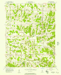
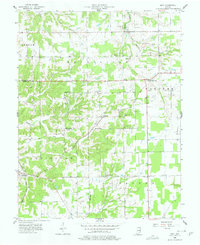
1950s Maps of Scott County, Indiana
Explore 9 historic maps of Scott County from the 1950s. These maps offer a rare glimpse into what life looked like during the 1950s — showing old roads, neighborhoods, homes, and landmarks that have changed or disappeared over time.
Whether you're researching your family's past, planning a metal detecting trip, or studying how Scott County's landscape evolved across the 1950s, these high-resolution maps are a powerful tool for exploring the history of this region.
- Focus on a specific era: All maps on this page are from the 1950s, giving you a focused view of this time period.
- See what’s changed: Compare century-old streets, trails, and buildings to today's modern landscape using overlays and satellite layers.
- Research with precision: Use these maps for genealogy, historical research, land use analysis, or educational projects.
- View, download, or print: Maps are fully viewable online in high resolution, and can be downloaded or printed for your own records.
Start exploring Scott County's history through authentic maps from the 1950s. This is your window into the past.
Scott County, IN maps
(9)- 1955 Map of South Boston, 1956 Print
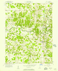
 1955 South Boston1956 Print · USGSThe rural borderlands of Washington and Clark Counties are captured here in the mid-fifties, during a time of active country parishes and small local schools. Genealogists and historians can locate vanished landmarks like Polk Sch, the Mead Cem, and the village of South Boston.4 unique versions available
 - 1956 Map of Otisco, 1957 Print
 1956 Otisco1957 Print · USGSMid-century Clark County is defined here by the unique diagonal boundaries of the Clark Military Grant and the busy Baltimore and Ohio rail line. Genealogists can locate family sites at Walnut Hill Cem, Clegg Sch, and the small settlement of Marysville.3 unique versions available
 - 1956 Map of Blocher, 1957 Print
 1956 Blocher1957 Print · USGSSouthern Indiana's rural landscape is captured here in the mid-fifties as the Baltimore and Ohio railroad passes through Blocher. Researchers can trace family history through sites like Scaffold Lick Ch and the extensive Clark Military Grant.
 - 1956 Map of Kent, 1957 Print
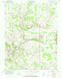
 1956 Kent1957 Print · USGSSouthern Indiana farming communities and rural townships are documented here during the mid-1950s. Genealogists can trace family landmarks and burial sites like White River Cem and Horner Cem, or locate centers of local life like New Bethel Ch.4 unique versions available
 - 1956 Map of Deputy, 1957 Print
 1956 Deputy1957 Print · USGSSouthern Indiana rail and river life are captured here in the mid-fifties, centered on the Baltimore and Ohio line. Genealogists can trace family names through landmarks like Robertson Cem, Alpha Ch, and the settlement of Deputy.
 - 1956 Map of New Washington, 1957 Print
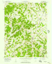
 1956 New Washington1957 Print · USGSSouthern Indiana's rural landscape comes into focus during the mid-fifties, showing the township lines and creek-carved valleys of Clark and Scott counties. Researchers can trace ancestral property near New Washington or locate remote sites like Barries Cem and the Pleasant View Ch.4 unique versions available
 - 1956 Map of Louisville, 1971 Print
 1956 Louisville1971 Print · USGSThe Ohio River valley and the Kentucky Bluegrass are captured here during a period of rapid mid-century growth and industrial activity. Genealogists and historians can trace rail-centered towns and military land use at Fort Knox and the Jefferson Proving Ground.2 unique versions available
 - 1958 Map of Little York, 1959 Print
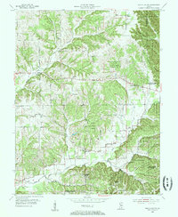
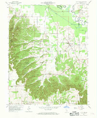 1958 Little York1959 Print · USGSWashington and Scott Counties are captured here in the late fifties, showcasing a rural Indiana landscape of ridge-top churches and forested hollows. Researchers can trace family sites at McKnight Cem, visit the settlement of Pumpkin Center, or locate the old Township Sch.6 unique versions available
 - 1959 Map of Crothersville, 1960 Print
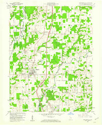 1959 Crothersville1960 Print · USGSSoutheast Indiana's rural landscape is captured here in the late fifties, centered on the growing community of Crothersville. Genealogists and historians can trace family roots through numerous landmarks like Marion Ch, Bethany Cem, and the small siding at Retreat.
End of results
Showing maps 1-9 of 9
Top cities of Scott County
Frequently asked questions
- What are the different types of historical maps available for Scott County?
- What is the oldest map of Scott County?
- Where can I purchase historical maps of Scott County for my home or office?
- Where can I download high-res historical maps of Scott County?
- Are there historical topographic maps available for Scott County?
- Is there historical aerial imagery available for Scott County?
- Where are historical maps of Scott County sourced from?