1960s Maps of Marion, Indiana
Explore 1 historic maps of Marion from the 1960s. These maps offer a rare glimpse into what life looked like during the 1960s — showing old roads, neighborhoods, homes, and landmarks that have changed or disappeared over time.
Whether you're researching your family's past, planning a metal detecting trip, or studying how Marion's landscape evolved across the 1960s, these high-resolution maps are a powerful tool for exploring the history of this region.
- Focus on a specific era: All maps on this page are from the 1960s, giving you a focused view of this time period.
- See what’s changed: Compare century-old streets, trails, and buildings to today's modern landscape using overlays and satellite layers.
- Research with precision: Use these maps for genealogy, historical research, land use analysis, or educational projects.
- View, download, or print: Maps are fully viewable online in high resolution, and can be downloaded or printed for your own records.
Start exploring Marion's history through authentic maps from the 1960s. This is your window into the past.
Marion, IN maps
(1)- 1962 Map of Shelbyville, 1964 Print
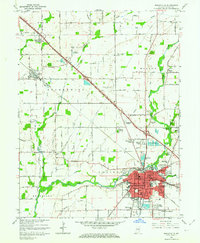 1962 Shelbyville1964 Print · USGSShelbyville and its surrounding townships are captured in the early sixties as mid-century suburbs began to expand alongside established rural centers. Genealogists and local historians can locate several country churches, including Old Union Ch and Brandywine Ch, or trace the tracks of the New York Central railroad.4 unique versions available
End of results
Showing maps 1-1 of 1
Top cities near Marion
- Indianapolis historical maps
- Shelbyville historical maps
- Greenfield historical maps
- Needham historical maps
- New Palestine historical maps
- Knightstown historical maps
See more
Frequently asked questions
- What are the different types of historical maps available for Marion?
- What is the oldest map of Marion?
- Where can I purchase historical maps of Marion for my home or office?
- Where can I download high-res historical maps of Marion?
- Are there historical topographic maps available for Marion?
- Is there historical aerial imagery available for Marion?
- Where are historical maps of Marion sourced from?