1940s Maps of Sullivan County, Indiana
Explore 16 historic maps of Sullivan County from the 1940s. These maps offer a rare glimpse into what life looked like during the 1940s — showing old roads, neighborhoods, homes, and landmarks that have changed or disappeared over time.
Whether you're researching your family's past, planning a metal detecting trip, or studying how Sullivan County's landscape evolved across the 1940s, these high-resolution maps are a powerful tool for exploring the history of this region.
- Focus on a specific era: All maps on this page are from the 1940s, giving you a focused view of this time period.
- See what’s changed: Compare century-old streets, trails, and buildings to today's modern landscape using overlays and satellite layers.
- Research with precision: Use these maps for genealogy, historical research, land use analysis, or educational projects.
- View, download, or print: Maps are fully viewable online in high resolution, and can be downloaded or printed for your own records.
Start exploring Sullivan County's history through authentic maps from the 1940s. This is your window into the past.
Sullivan County, IN maps
(16)- 1940 Map of Lewis
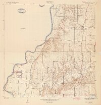
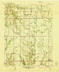 1940 Lewis1940 Print · USGSVigo and Sullivan counties are shown here just before the Second World War as coal mining and rail transport shaped the local economy. Researchers can trace family history through sites like Smith Cem or locate industrial landmarks like the Blackhawk Mine and Brown Jug Corner.
 - 1940 Map of Linton
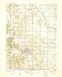
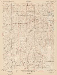
 1940 Linton1940 Print · USGSLinton and its surrounding coalfields are captured in the late thirties, showcasing a landscape shaped by heavy industry and rail. Genealogists and historians can locate vanished country landmarks like Morris Chapel, Victoria, and Sassafras Sch among the early Strip Mine sites.2 unique versions available
 - 1940 Map of Jasonville
 1940 Jasonville1940 Print · USGSJasonville and the surrounding coalfields are captured in the late 1930s, showing a landscape defined by industry and rural community. Genealogists can locate family landmarks like Sanderson Cem, Little Flock Ch, and Listen Sch.2 unique versions available
 - 1940 Map of Pimento
 1940 Pimento1940 Print · USGSVigo and Sullivan Counties are shown in the late 1930s, capturing the rural character of the Indiana prairie before modern development. Genealogists can trace family roots through numerous local landmarks, including Kester Cem, Farmers Chapel, and the settlement of Prairie Creek.2 unique versions available
 - 1942 Map of Fairbanks
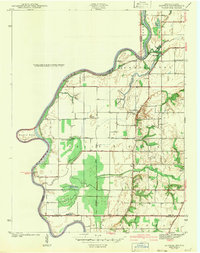
 1942 Fairbanks1942 Print · USGSSullivan County, Indiana, is captured here in the early 1940s as a landscape of river-bend farms and historic family plots. Genealogists and local historians can trace the Harrison Trail or locate ancestral sites like Pogue Cem, Johnson Cem, and the York Ferry river crossing.2 unique versions available
 - 1942 Map of Shelburn
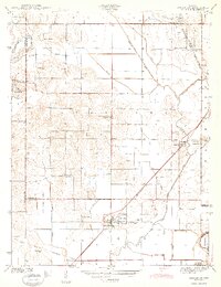
 1942 Shelburn1942 Print · USGSWestern Indiana coal and rail life are captured here in the early 1940s, as mining towns thrived along the corridor. Trace local family roots at Ebenezer Cem or explore the rail hubs of Shelburn and Curryville near the Linda Lou Mine.2 unique versions available
 - 1942 Map of Hutton
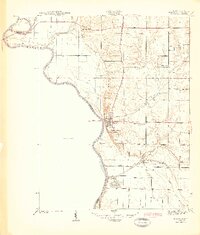
 1942 Hutton1942 Print · USGSThe Indiana-Illinois borderlands along the Wabash River are captured here in the early 1940s, showing a landscape of bayous and ferries. Researchers can trace historic river crossings at Darwin Ferry and locate family burial sites at Shattuck Cem and Lykens Cem.2 unique versions available
 - 1942 Map of Birds, 1958 Print
 1942 Birds1958 Print · USGSThe Wabash River valley comes to life in this mid-century survey of the Illinois-Indiana borderlands. Genealogists can locate family lands near Oil Grove or trace ancestors through rural landmarks like Buncombe School and Brightlight Ferry.
 - 1943 Map of Merom
 1943 Merom1943 Print · USGSThe Wabash River bluffs of Sullivan County are documented here during the early years of the war. Researchers can trace family history through several local landmarks like Merom Institute, the Old French Cem, and the river community of Riverton.2 unique versions available
 - 1943 Map of Hymera
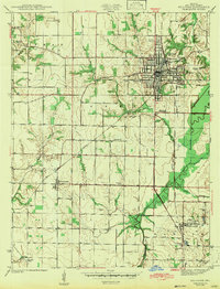
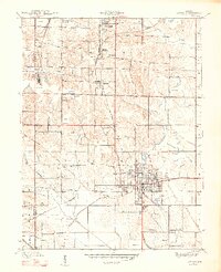
 1943 Hymera1943 Print · USGSSullivan County was a bustling coal corridor in the early 1940s, where heavy rail lines connected numerous active mining sites. Researchers can trace the lineage of small communities and family-named sites like Miner City, Nye Chapel, and the Jackson Hill Mine.2 unique versions available
 - 1943 Map of Carlisle
 1943 Carlisle1943 Print · USGSSouthern Sullivan County was a landscape of rail-linked towns and quiet country cemeteries in the years following the Great Depression. Genealogists and local historians can trace family roots through sites like Odd Fellows Cem or locate the old Shaker Prairie Ch along the Vincennes Tract.2 unique versions available
 - 1943 Map of Sandborn
 1943 Sandborn1943 Print · USGSIn the early 1940s, this portion of Knox and Greene Counties was a busy corridor for coal mining and rail transport. Researchers can trace family history through local landmarks like Marco Cem, Pleasant Grove Ch, and the many Strip Mine works near Sponsler.2 unique versions available
 - 1943 Map of Sullivan
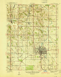
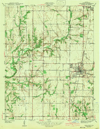
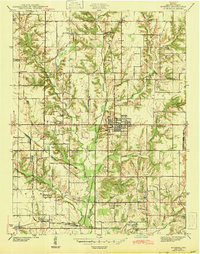
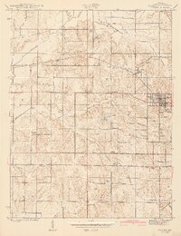
 1943 Sullivan1943 Print · USGSSullivan County during the early 1940s reveals a structured landscape of rail-dependent towns and rural family farmsteads. Researchers can trace the routes of the Illinois Central and locate dozens of local landmarks like Depot Town and Mt Zion Cem.2 unique versions available
 - 1943 Map of Dugger
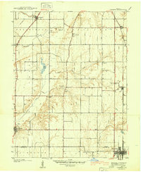
 1943 Dugger1943 Print · USGSSullivan County’s coal-mining country is captured here during the 1940s, showing a landscape defined by rail lines and extraction. Researchers can trace family history through local landmarks like Dugger Cem, Center Sch, and small settlements like Caledonia and Jericho.2 unique versions available
 - 1944 Map of Bucktown
 1944 Bucktown1944 Print · USGSThe rural borders of Sullivan and Knox counties appear here during the early 1940s as traditional farming life met industrial coal extraction. Genealogists can locate family burial grounds like Land Cem and McDade Cem or rural centers such as Bucktown and Pleasantville.2 unique versions available
 - 1947 Map of Linton
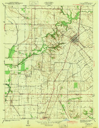
 1947 Linton1947 Print · USGSGreene County is seen during a period of industrial transition in the late 1940s, when coal mining and rail transport defined the local economy. Researchers can locate family-named landmarks and rural hubs such as Wright High Sch, Antioch Ch, and the settlement of Island City.3 unique versions available
End of results
Showing maps 1-16 of 16
Top cities of Sullivan County
- Sullivan historical maps
- Cass historical maps
- Shelburn historical maps
- Farmersburg historical maps
- Dugger historical maps
- Hymera historical maps
See more
Frequently asked questions
- What are the different types of historical maps available for Sullivan County?
- What is the oldest map of Sullivan County?
- Where can I purchase historical maps of Sullivan County for my home or office?
- Where can I download high-res historical maps of Sullivan County?
- Are there historical topographic maps available for Sullivan County?
- Is there historical aerial imagery available for Sullivan County?
- Where are historical maps of Sullivan County sourced from?