1970s Maps of Sullivan County, Indiana
Explore 2 historic maps of Sullivan County from the 1970s. These maps offer a rare glimpse into what life looked like during the 1970s — showing old roads, neighborhoods, homes, and landmarks that have changed or disappeared over time.
Whether you're researching your family's past, planning a metal detecting trip, or studying how Sullivan County's landscape evolved across the 1970s, these high-resolution maps are a powerful tool for exploring the history of this region.
- Focus on a specific era: All maps on this page are from the 1970s, giving you a focused view of this time period.
- See what’s changed: Compare century-old streets, trails, and buildings to today's modern landscape using overlays and satellite layers.
- Research with precision: Use these maps for genealogy, historical research, land use analysis, or educational projects.
- View, download, or print: Maps are fully viewable online in high resolution, and can be downloaded or printed for your own records.
Start exploring Sullivan County's history through authentic maps from the 1970s. This is your window into the past.
Sullivan County, IN maps
(2)- 1974 Map of Carlisle, 1975 Print
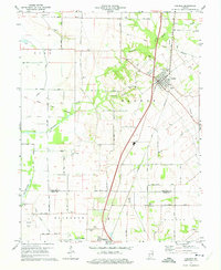 1974 Carlisle1975 Print · USGSCarlisle and Oaktown are captured in the mid-1970s at the junction of two major rail lines. Genealogists can locate numerous burial sites like Old Town Cem and Haddon Cem, or trace the path of the Old Indian Treaty Boundary across the countryside.2 unique versions available
 - 1974 Map of Sullivan, 1975 Print
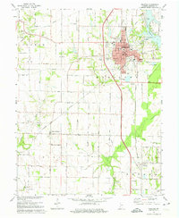 1974 Sullivan1975 Print · USGSSullivan and its surrounding townships are captured here in the mid-seventies, showing a landscape defined by rail transport and agriculture. Researchers can locate numerous family burial sites like Timmons Cem, explore the village of New Lebanon, or trace the OIL FIELD developments.2 unique versions available
End of results
Showing maps 1-2 of 2
Top cities of Sullivan County
- Sullivan historical maps
- Cass historical maps
- Shelburn historical maps
- Farmersburg historical maps
- Dugger historical maps
- Hymera historical maps
See more
Frequently asked questions
- What are the different types of historical maps available for Sullivan County?
- What is the oldest map of Sullivan County?
- Where can I purchase historical maps of Sullivan County for my home or office?
- Where can I download high-res historical maps of Sullivan County?
- Are there historical topographic maps available for Sullivan County?
- Is there historical aerial imagery available for Sullivan County?
- Where are historical maps of Sullivan County sourced from?